CWA warns storm effect at top in next two days
FRIDAY, SATURDAY: While Typhoon Champi might weaken, officials warned about large waves, while some transport services and tourist spots have been affected
Typhoon Champi is forecast to have the greatest effect on Taiwan tomorrow and on Saturday, with a sea warning issued late last night and a land warning expected afternoon today, the Central Weather Administration (CWA) said yesterday.
The storm’s projected track has shifted slightly westward and it could begin moving away from Taiwan toward Japan’s Kyushu island on Saturday, with the warnings potentially lifted as early as Saturday afternoon, CWA forecaster Chang Cheng-chuan (張承傳) said.
As of yesterday afternoon, Champi was about 910km east-southeast of Oluanpi (鵝鑾鼻), Taiwan proper’s southernmost point, CWA data showed.

People shop for food at a market in Taipei’s Beitou District yesterday as Typhoon Champi approaches Taiwan. A sea warning was issued late last night, while a land warning is expected later today.
Photo: CNA
Its maximum sustained winds had weakened slightly to 209kph from 216kph, but its storm radius is expected to expand to up to 300km as it approaches Taiwan, Chang said.
The typhoon could weaken to the lower end of a severe typhoon or the upper end of a moderate typhoon over the next few days, as conditions are expected to become less favorable for its development after it turns north, he said.
Rain is forecast across Taiwan tomorrow, with localized heavy or extremely heavy rain possible in mountainous areas of northern Taiwan, while Taichung and mountainous areas in eastern Taiwan could have localized heavy rain, the CWA said.
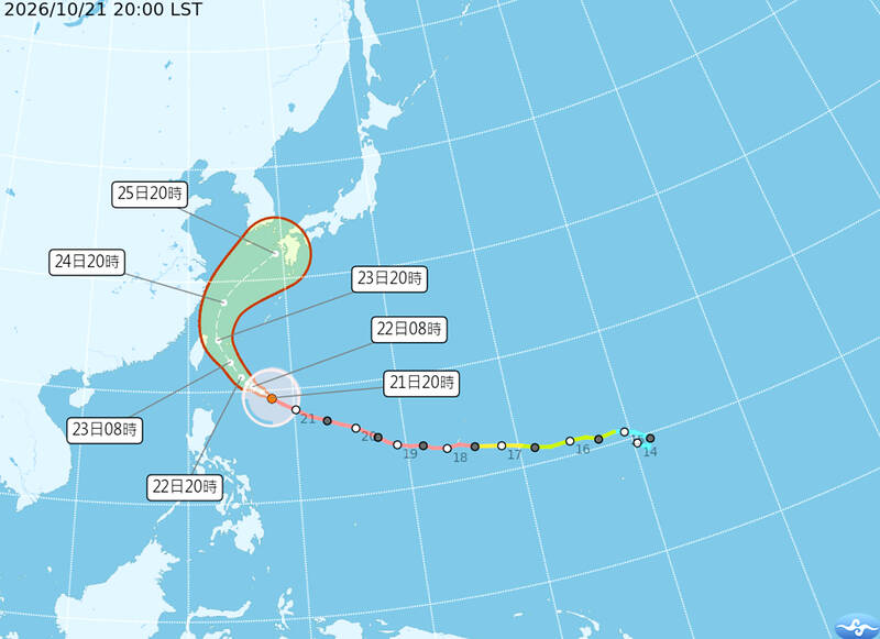
A graphic shows the forecast path of Typhoon Champi.
Photo: Screen grab from the Central Weather Administration’s Web site
Other areas could experience scattered brief showers, it said.
On Saturday, brief showers and localized heavy rain is forecast for northern Taiwan, while eastern Taiwan and mountainous areas of central Taiwan are expected to have isolated showers, it said.
The storm is expected to move farther away on Sunday and Monday, although localized brief showers could persist in areas north of Taoyuan, eastern Taiwan and the Hengchun Peninsula, with scattered afternoon showers in mountainous areas elsewhere, it said.
The northeasterly monsoon is expected to bring cooler weather to northern Taiwan and Yilan County today, with daytime highs of about 24°C and lows of 21°C, Chang said.
Temperatures are forecast to rise slightly from Saturday to Monday, with highs of 29°C to 34°C nationwide, before another strengthening of the monsoon brings cooler conditions to northern Taiwan and Yilan on Tuesday, he said.
The public should beware of large waves from today through Saturday along the Keelung coast, northern and central coastal areas, the eastern coast, the Hengchun Peninsula, and Penghu and Lienchiang counties, as well as around Orchid Island (Lanyu, 蘭嶼) and Green Island, he said.
Foehn winds could push temperatures above 36°C in southeastern Taiwan tomorrow and on Saturday, the CWA said.
As Champi is approaching Taiwan, government agencies have stepped up disaster preparations, suspending some transport services and closing several tourist destinations, while airlines have canceled flights between Taiwan and Okinawa scheduled for today.
China Airlines (CAL) canceled six flights between Taiwan and Okinawa today, including services linking Taoyuan, Taichung and Kaohsiung with the Japanese island, and brought forward two other Taichung-Okinawa flights.
Tigerair Taiwan canceled several flights connecting Taoyuan, Kaohsiung, Taichung and Tainan with Okinawa.
Starlux Airlines and EVA Airways said their international flights had not yet been affected, but warned that weather conditions could prompt schedule changes.
Domestic carriers Mandarin Airlines and Uni Air also announced cancelations on several routes, while some services would be adjusted.
The Maritime and Port Bureau said several domestic ferry routes, including Keelung-Lienchiang and Kaohsiung-Magong, would be suspended today.
The Kinmen-Xiamen ferry service would also stop operating in both directions from 8:30am today, it said.
The Coast Guard Administration warned that coastal conditions are expected to deteriorate, with long-period swells already occurring.
People who enter restricted coastal areas could face fines of up to NT$250,000, it said.
Several tourist attractions are to close from noon today, including Wuling (武陵) and Fushoushan (福壽山) farms in central Taiwan and Taipingshan (太平山) National Forest Recreation Area in Yilan County.
Gueishan Island (龜山島) will also be closed for three days.
An army open-house event originally scheduled for Saturday at Chengkungling in Taichung has been postponed to Oct. 31, while a riverside arts event and water fireworks display in New Taipei City’s Yonghe District (永和) have been rescheduled for Saturday next week.
The Water Resources Agency has ordered river management offices to coordinate with local governments on flood preparations, including clearing drainage systems and checking flood-control equipment.
New Taipei City is deploying additional mobile pumps in low-lying areas of Wanli (萬里), Jinshan (金山) and Shimen (石門) districts.
President William Lai (賴清德) urged the public not to underestimate the storm even if it does not make landfall, while the Executive Yuan’s disaster response office called on central and local authorities to prepare for heavy rain, flooding, landslides, strong winds and dangerous waves.
KioskNews shows a cleaned-up reading view extracted from the publisher’s page — the original always lives on their site, not ours.