וואלהאירוע ירי בטמרה - חשוד נעצרCNN TürkİSTANBULKART 1 TL ÖĞRENCİ ABONMAN BAŞVURUSU 2026| İBB aylık 1 TL öğrenci abonmanı başvurusu nasıl yapılır, kimler başvurabilir?PunchFlood alert: Lagos orders vulnerable residents to relocateESPN DeportesMéxico apunta a Monterrey para jugar en noviembreInquirerVP trial Day 28: Defense to cross-examine SEC execBollywood HungamaThe Vvaan makers acquire sync rights after Sargam Vaish’s copyright claim over ‘Aigiri Nandini’ESPNDart's injury hinders Giants as Stafford, Rams pick up MNF winInquirer EntertainmentAnne Curtis responds to ‘retokada’ claims, comments about daughter DahliaSözcüÖdülü duyan sokak sokak aramaya çıktı: 3 milyon lira verilecekBusiness AMDe oorlogen in Oekraïne en Iran bewijzen hoe hard moderne oorlogsvoering is veranderd20 MinutenRettungshund Tsunami erhält zum Ruhestand eine StatueCumhuriyet2026 KYK burs ve kredi başvuruları ne zaman başlayacak? GSB başvuru tarihleri, şartları ve e-devlet adımları
The Daily Newsstand · Free, Always
Tuesday, September 22, 2026

LPA outside PAR has high chance to become tropical depression
Translate
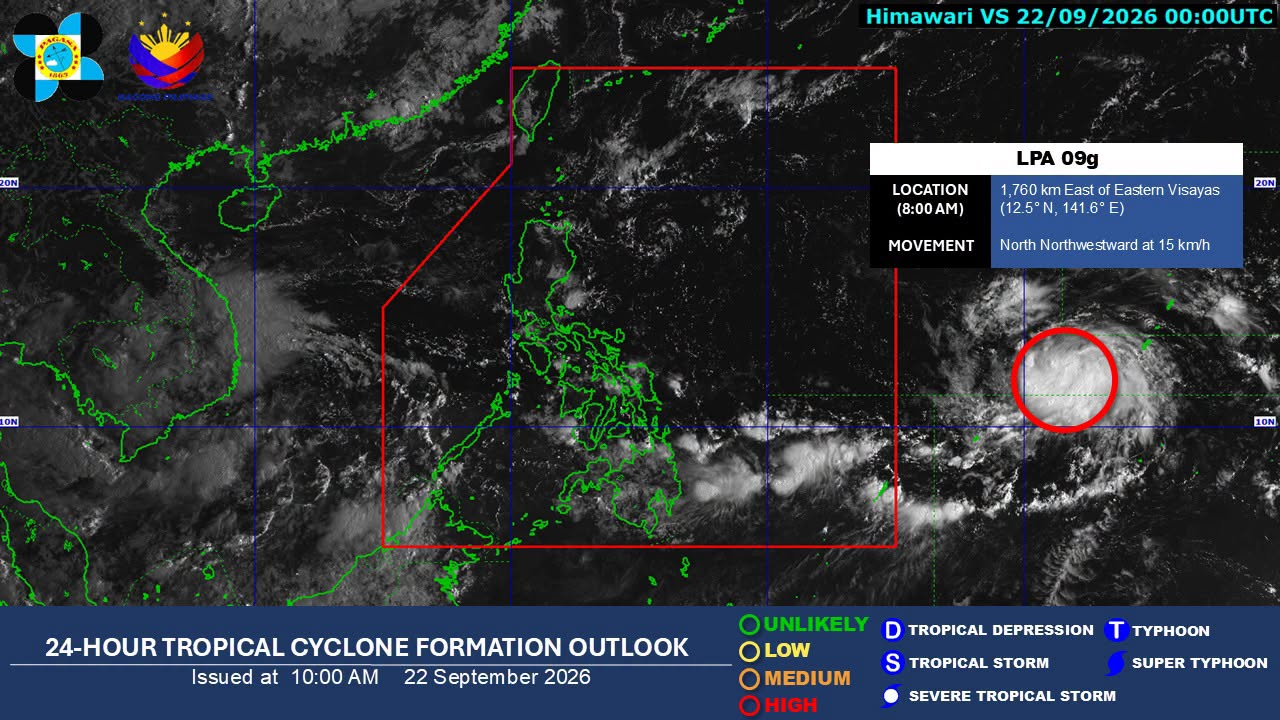
24-hour tropical cyclone formation outlook issued by Pagasa at 10 a.m. on September 22, 2026. (Photo by Pagasa/Facebook)

MANILA, Philippines – The low pressure area (LPA) outside the Philippine area of responsibility (PAR) has a “high chance” of developing into a tropical depression within the next 24 hours, the state weather bureau said on Tuesday.

READ: Trough of LPA outside PAR to affect parts of Visayas, Mindanao Tuesday

This is based as of 8 a.m. on the 24-hour tropical cyclone formation outlook issued by the Philippine Atmospheric, Geophysical, and Astronomical Services Administration (Pagasa) issued at 10 a.m. 

Article continues after this advertisement

The LPA was last estimated 1,760 kilometers east of Eastern Visayas, moving north-northwest at 15 kilometers per hour. 

FEATURED STORIES

NEWSINFO

NEWSINFO

NEWSINFO

In its separate 5 a.m. weather forecast, Pagasa said that the LPA may enter the PAR in the coming days.

Once it becomes a tropical depression inside the country, it will be given its local name Queenie.  /gsg

View the original on Inquirer

KioskNews shows a cleaned-up reading view extracted from the publisher’s page — the original always lives on their site, not ours.