Snow forecast for Taiwan’s highest peaks late this week
Snow could fall on Taiwan’s mountains above 3,500 meters starting Thursday night and continuing into Friday as northeasterly winds bring colder weather, the Central Weather Administration (CWA) said yesterday.
Besides bringing the first snowfall of the season, the cold spell could send temperatures plunging to as low as 11°C in some low-lying areas between Friday and Sunday, said CWA forecaster Huang En-hung (黃恩鴻).
Prior to this happening, northeasterly winds currently affecting Taiwan would weaken today, bringing warmer temperatures and scattered showers to northern and eastern parts of the country and the Hengchun Peninsula (恆春半島) in the south, Huang said.
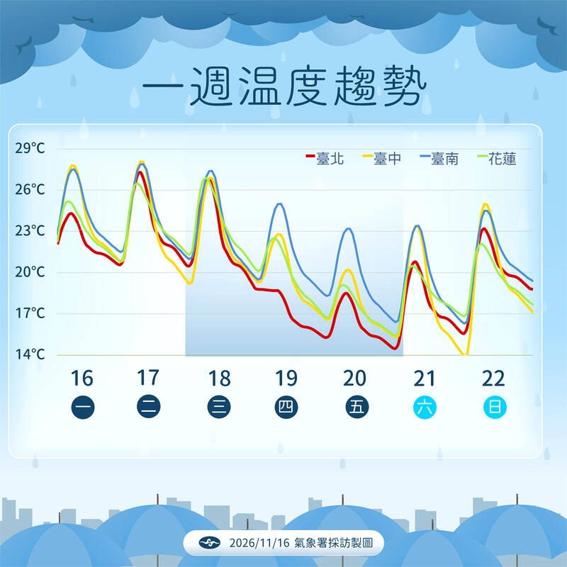
A chart shows the weather forecast for this week. The red line represents Taipei, the yellow line represents Taichung, the blue line represents Tainan, and the green line represents Hualien.
Photo provide by the Central Weather Administration
The winds are expected to strengthen again tomorrow, bringing increased moisture across the country, he said.
Temperatures will begin to fall on Thursday, with highs reaching only 18-20°C in the north and the northeast, and 23-25°C elsewhere.
Friday and Saturday are expected to be the coldest days this week, with average lows of 14-15°C in northern, central, and northeastern parts of the country, Huang said.
KioskNews shows a cleaned-up reading view extracted from the publisher’s page — the original always lives on their site, not ours.