HCMC battles flooding as aging infrastructure struggles against intensifying rains, tides

Ho Chi Minh City has addressed flooding in many places, yet its fragmented infrastructure, delayed works, and increasing rainfall and high tides mean many areas still suffer from severe waterlogging.
Heavy rains from late September to early October caused severe flooding along many roads, disrupting traffic.
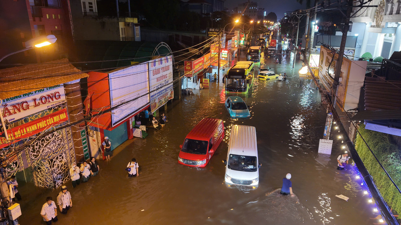
On the afternoon of Sept. 30, Phan Huy Ich Street in Tan Son Ward was under nearly a meter of water along an 800-meter stretch, according to the Center for Transport and Technical Infrastructure Management.
A woman named Phuong Thanh, 33, who lives at Phuc Yen 1 Apartment Building on the street, said it often floods during heavy rains, but never as badly as on that day.
"The water reached an adult's waist," said Thanh, who decided to leave her motorbike at a shop and waded home to be safer.
 |
|
Floodwaters rise by more than 1m along Phan Huy Ich Street in Ho Chi Minh City on Sept. 30, 2026. Photo by VnExpress/Thanh Tung |
According to the Construction Department, Phan Huy Ich Street lies at the intersection of several small drainage basins.
Most of the water flows into the Hy Vong Canal before draining into the Tham Luong-Ben Cat Canal, but the aging drain pipes there are too narrow to handle the volume, while the canal has also deteriorated and been encroached upon.
It receives runoff from multiple roads, which often overwhelms the drainage system.
This problem is not limited to Phan Huy Ich.
Ho Chi Minh City now has 159 frequent flooding hotspots, including 76 in the former city, ranging from severe to minor. The rest are in the former Binh Duong and Ba Ria-Vung Tau provinces that were merged into the city last year.
Fifty are classified as severely flooded.
According to the construction department's review of the city's flood-control program before the redrawing of the provincial borders, HCMC had 126 major roads prone to rain-related flooding and 95 affected by high tides in 2008.
But more than 80% of the roads have been fixed since.
Improvement works along the Nhieu Loc-Thi Nghe and Tan Hoa-Lo Gom canals have helped resolve flooding in many areas, but some streets like Nguyen Van Khoi, Phan Huy Ich, Le Van Luong, and Tran Xuan Soan remain in bad shape.
The city has about 7,200 km of drainage pipes, 1,700 outfalls, more than 500 tidal-control valves, and tidal-control sluices and river embankments.
Its nearly 1,000 km of canals and waterways serve as natural drainage routes.
Most of this infrastructure is concentrated in the former HCMC, and was developed under two major drainage and flood-control plans, Plans 752 and 1547.
One plan focused on developing the drainage network and improving urban canals and waterways, and the other involved building embankments and tidal-control gates.
 |
|
Floodwaters beneath Ba Son Bridge on the Thu Thiem side in HCMC on the evening of Oct. 7, 2026. Photo by VnExpress/Dinh Van |
Assoc. Prof. Nguyen Phu Quynh, deputy director of the Southern Institute of Water Resources Research, said that, before 2008, the city largely followed an approach of "fighting floods wherever they occurred," before gradually shifting toward basin-wide flood management.
However, delays in completing many projects have limited their effectiveness, with a notable example being the VND10 trillion (US$400 million) flood-control network, which, when completed, is expected to protect around 6.5 million people from flooding with six tidal-control sluice gates.
Began in 2016, it has yet to be completed.
Dr. Nguyen Huu Nguyen of the Ho Chi Minh City Association for Urban Planning and Development said the drainage system is also under growing pressure from urbanization and changing rainfall and tidal patterns.
He said major drainage pipes were previously designed for around 85 mm of rain over three hours and a peak tide of 1.32 m, but in recent years, rainfall in that period has often exceeded 100 mm, while tides at Phu An Station at the Bach Dang Wharf Park have recently reached 1.75 meters on several occasions.
On Sept. 30 Phan Huy Ich Street received 79 mm of rain in just 45 minutes, well above the rainfall level it can cope with, it placed further pressure on the aging drainage system and overloaded canals, he said.
He said the expanding concrete surfaces have reduced the soil's natural ability to absorb water. Water on the streets must pass through inlets, secondary drains, main drainage pipes, and canals before reaching rivers. Many old and undersized pipes are obstructed by garbage or lack proper connections, preventing water from draining quickly enough.
"This explains why areas such as the former Go Vap and Thu Duc districts, despite being on higher ground, still frequently flood."
Le Ngoc Linh, deputy director of the construction department, said the differences in terrain and hydrological conditions have made flood control more complex, especially with the impacts of extreme rainfall, high tides, sea-level rise, and land subsidence.
The city is currently divided into 23 major drainage basins as the basis for flood management.
Flood-control measures must thus consider the entire path of the water flow rather than simply improving the location where flooding occurs.
87 projects completed by 2030
Under a new plan, HCMC expects to complete 87 projects between now and 2030 at a cost of VND142.34 trillion ($5.4 billion), targeting mitigation of 50 severe flooding spots.
This year, three locations are expected to be cleared: Phan Van Hon and Binh Quoi streets, and the National Highway 51-Huynh Thuc Khang area in the former Ba Ria-Vung Tau.
Key projects include the VND10 trillion tidal-control project, improvements to the Tham Luong-Ben Cat, Xuyen Tam, and Van Thanh canals, and drainage systems in several areas.
The tidal-control project includes six major gates and embankments along the Saigon River that will address eight tidal flooding hotspots.
From 2028 to 2030, the city plans to complete another 33 projects at a cost of VND73 trillion to fix 17 severe flooding hotspots.
 |
|
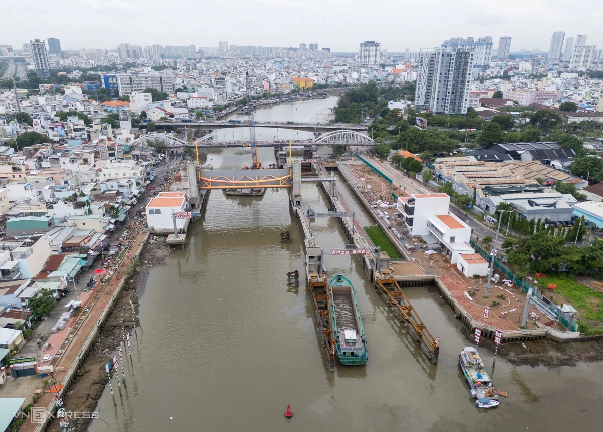
The Tan Thuan sluice gate, which has a 230-ton gate and a ship lock on the Te Canal in HCMC, is about 95% complete. It is one of six sluice gates of the VND10-trillion tidal-control project. Photo by VnExpress/Quynh Tran |
Embankments, tidal-control gates, and pumping stations will be built as a closed system, while the drainage network will be upgraded to new standards.
The city also plans to build retention ponds, restore water-storage areas, relocate homes along canals through some 43 projects, and improve waterways and public spaces.
Protection against high tides does not necessarily mean an end to rain-related flooding if the drainage system remains inadequate.
Regarding the VND10 trillion tidal-control project, Quynh of the Southern Institute of Water Resources Research urged the city to accelerate construction of embankments, revetments, and gates to complete the system.
"The project will struggle to reach its full potential without connecting infrastructure to create a continuous tidal-control belt in the area."
KioskNews shows a cleaned-up reading view extracted from the publisher’s page — the original always lives on their site, not ours.