Rosal downgraded to typhoon east of Batanes

Already have Rappler+?
to listen to groundbreaking journalism.
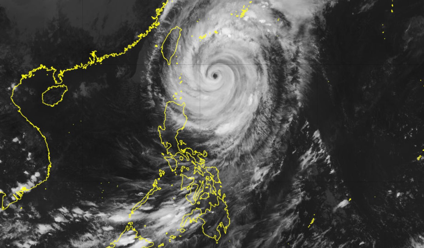
ROSAL. Satellite image of Typhoon Rosal (Champi) as of October 22, 2026, 4 pm.
JMA
The maximum sustained winds of Typhoon Rosal (Champi) are down to 165 km/h as of Thursday afternoon, October 22
AT A GLANCE
- Rosal (Champi) weakened into a typhoon on Thursday afternoon, October 22.
- Batanes and Cagayan are still seeing significant rain due to Rosal.
This is AI-generated. Read the article for full context. Report any errors.
MANILA, Philippines – Rosal (Champi) weakened from a super typhoon into a typhoon on Thursday afternoon, October 22, but rainfall and wind warnings have yet to be lifted for portions of Northern Luzon.
The Philippine Atmospheric, Geophysical, and Astronomical Services Administration (PAGASA) said in its 5 pm bulletin on Thursday that Rosal’s maximum sustained winds are down to 165 kilometers per hour. Its gustiness has also eased to 205 km/h.
At its peak, Rosal had maximum sustained winds of 215 km/h.
As of 4 pm on Thursday, the typhoon was located 350 kilometers east of Itbayat, Batanes, moving northwest at only 15 km/h. It will be at its closest point to extreme Northern Luzon between Thursday afternoon and Friday morning, October 23.
PAGASA said Rosal will continue to trigger heavy to intense rain in Batanes (100-200 millimeters) and moderate to heavy rain in Cagayan (50-100 mm) in the next 24 hours.
On Thursday evening, the typhoon may also bring rain with gusty winds to Ilocos Norte, Apayao, and Isabela, as well as scattered rain and thunderstorms to the rest of the Cordillera Administrative Region, the rest of Cagayan Valley, Ilocos Sur, La Union, and Aurora.
The weather bureau added that Rosal’s trough or extension might cause scattered rain and thunderstorms in Bicol, the Zamboanga Peninsula, Western Visayas, the Negros Island Region, Lanao del Norte, Misamis Occidental, and Palawan.
Meanwhile, here are the areas under tropical cyclone wind signals as of 5 pm on Thursday:
Signal No. 2
Gale-force winds (62 to 88 km/h), minor to moderate threat to life and property
- Batanes
- northeastern part of Babuyan Islands (Babuyan Island)
Signal No. 1
Strong winds (39 to 61 km/h), minimal to minor threat to life and property
- rest of Babuyan Islands
- mainland Cagayan
- northeastern part of Isabela (Maconacon, Divilacan, Santa Maria, Cabagan, San Pablo, Palanan)
- Ilocos Norte
- Apayao
Signal No. 3 could be raised in Batanes, unless Rosal’s track shifts further north northwest.
The northeasterly windflow and the periphery or outer bands of the typhoon will also bring strong to gale-force gusts to the following areas:
Thursday, October 22
- most of Luzon and Visayas, Zamboanga Peninsula, Bangsamoro Autonomous Region in Muslim Mindanao, Northern Mindanao, Davao Region, Agusan del Norte, Surigao del Norte, Dinagat Islands, Sarangani
Friday, October 23
- most of Luzon and Visayas, Davao Region, Zamboanga del Norte, Misamis Occidental, Camiguin
Saturday, October 24
- Batanes, Babuyan Islands, Ilocos Norte, Polillo Islands, Bicol, Romblon, Capiz, Iloilo, Negros Occidental
Travel remains dangerous in seaboards affected by Rosal.
Up to very rough, high, or very high seas (travel is risky for all vessels)
- Northern and eastern seaboards of Batanes – waves up to 12 meters high
- Seaboard of Babuyan Islands; remaining seaboard of Batanes; northeastern seaboard of mainland Cagayan – waves up to 9 meters high
- Remaining seaboard of mainland Cagayan; seaboard of northern Isabela – waves up to 7 meters high
- Northern seaboard of Ilocos Norte – waves up to 6 meters high
- Remaining seaboards of Ilocos Norte and Isabela – waves up to 5.5 meters high
- Seaboards of Ilocos Sur and northern Aurora; northern and eastern seaboards of Polillo Islands and Catanduanes; northern seaboards of Camarines Norte and Camarines Sur – waves up to 4.5 meters high
Up to rough seas (small vessels should not venture out to sea)
- Seaboard of northern La Union; western seaboard of Pangasinan; northern seaboard of Northern Samar – waves up to 4 meters high
- Seaboard of northern Quezon; remaining seaboard of Aurora; eastern seaboards of Albay, Sorsogon, Northern Samar, and Eastern Samar – waves up to 3.5 meters high
- Seaboard of Zambales; eastern seaboards of Dinagat Islands and Siargao-Bucas Grande Islands – waves up to 3 meters high
Up to moderate to rough seas (small vessels should take precautionary measures or avoid sailing, if possible)
- Western seaboards of Bataan, Lubang Islands, and Surigao del Sur; remaining seaboards of La Union, Pangasinan, and Catanduanes – waves up to 2.5 meters high
- Western seaboards of Batangas, Cavite, and Calamian Islands; eastern seaboard of Davao Oriental; remaining seaboard of Lubang Islands – waves up to 2 meters high
ALSO ON RAPPLER
- DFA to China embassy: Escalatory, undiplomatic posts not helping bilateral ties
- [Puso at Diwa] Sara Duterte trial: Is the space for political impunity finally closing?
- Who is Ginbee Go, BPI’s next president and first female CEO?
Rosal is still projected to leave the Philippine Area of Responsibility by Friday evening or early Saturday morning, October 24. It entered PAR on Tuesday, October 20.
After leaving PAR, Rosal is likely to be downgraded to a severe tropical storm on Saturday.
Rosal is the Philippines’ 18th tropical cyclone for 2026, and the first for October. PAGASA earlier estimated the country may have one or two tropical cyclones during the month.
The Philippines is currently in a transition period to the northeast monsoon or amihan, following the end of the southwest monsoon or habagat, which was announced last October 5.
The northeast monsoon typically brings surges of cold temperatures, but the upcoming amihan period could be warmer as the existing strong El Niño in the tropical Pacific Ocean is predicted to become very strong in the fourth quarter of 2026. – Rappler.com
KioskNews shows a cleaned-up reading view extracted from the publisher’s page — the original always lives on their site, not ours.