Champi now a super typhoon again ahead of entry into PAR
Already have Rappler+?
to listen to groundbreaking journalism.
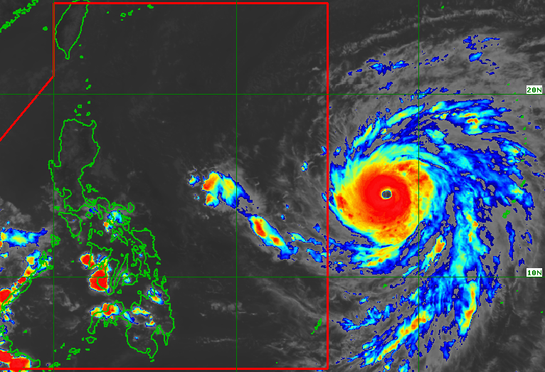
CHAMPI. Satellite image of Super Typhoon Champi outside the Philippine Area of Responsibility as of October 19, 2026, 4 pm.
PAGASA
The trough or extension of Super Typhoon Champi may already trigger scattered rain and thunderstorms in Catanduanes, Northern Samar, and Eastern Samar, says PAGASA on Monday afternoon, October 19
AT A GLANCE
- Champi re-intensified into a super typhoon outside the Philippine Area of Responsibility, with maximum sustained winds of 185 km/h.
- The super typhoon remains on track to enter PAR by Tuesday, October 20.
This is AI-generated. Read the article for full context. Report any errors.
MANILA, Philippines – Champi re-intensified into a super typhoon on Monday afternoon, October 19, ahead of its expected entry into the Philippine Area of Responsibility (PAR).
Champi’s maximum sustained winds increased from 175 kilometers per hour to 185 km/h, said the Philippine Atmospheric, Geophysical, and Astronomical Services Administration (PAGASA) in an advisory issued at 5 pm on Monday. Its gustiness is now up to 230 km/h from the previous 215 km/h.
The super typhoon was located 1,515 kilometers east of southeastern Luzon as of 4 pm, moving west northwest at a slightly slower 15 km/h from 20 km/h.
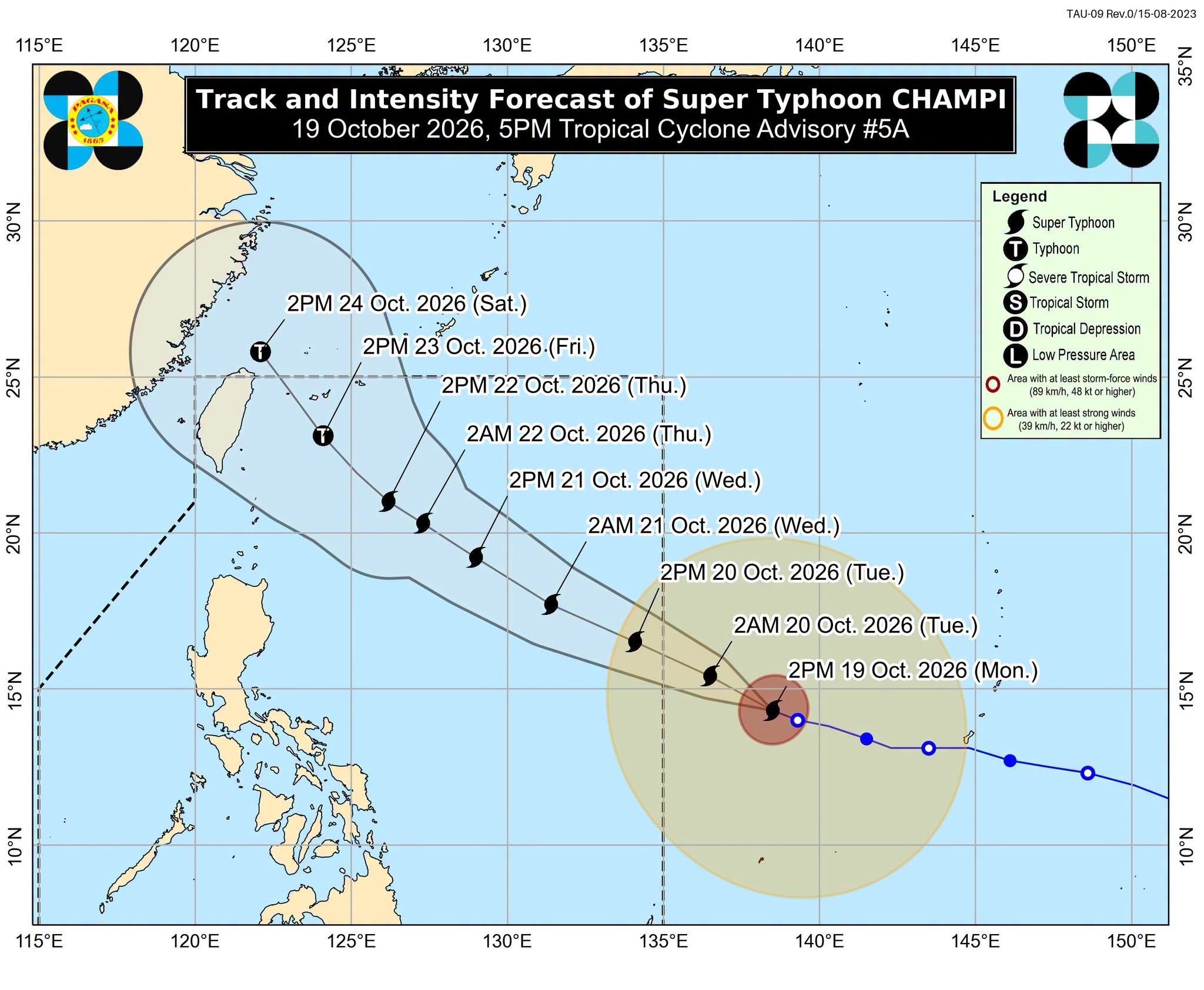
It is still projected to enter PAR by Tuesday morning or early afternoon, October 20. Upon entry, it will be given the local name Rosal.
PAGASA said Champi will continue to move west northwest until Wednesday, October 21, before moving generally northwest starting Thursday, October 22. It is likely to stay over the Philippine Sea, where it could strengthen further before gradually weakening Thursday onwards.
Even before Champi enters PAR, its trough or extension may already trigger scattered rain and thunderstorms in Catanduanes, Northern Samar, and Eastern Samar in the coming hours. Flash floods and landslides are possible.
The super typhoon could be closest to the Philippines’ northernmost province of Batanes on Friday, October 23. It is expected to bring heavy rain to extreme Northern Luzon, or the Batanes-Babuyan Islands area, even though it is unlikely to make landfall.
Tropical cyclone wind signals might also be raised for the northern and eastern portions of Northern Luzon and even parts of Bicol as early as Monday evening or Tuesday morning. The weather bureau’s latest forecast shows Signal No. 2 or 3 could be the highest, while Signal No. 4 is no longer seen as a possibility.
PAGASA added that most parts of Luzon and the Visayas, as well as portions of Mindanao, are likely to experience gusty conditions beginning Wednesday.
As for coastal conditions, moderate to rough waters are expected in the northern and eastern seaboards of Luzon and the eastern seaboards of the Visayas and Mindanao on Tuesday.
Starting Wednesday, very rough, high, or very high waters may affect the northern and eastern seaboards of Luzon.
Champi may exit PAR by Saturday, October 24.
ALSO ON RAPPLER
- Sandiganbayan suspends Marcoleta as senator over plunder case
- News Reflection: Bongbong Marcos didn’t get what he wanted
- Gasoline prices roll back as diesel goes up on October 20
Aside from the trough of the super typhoon, other sources of rain in the coming hours include the intertropical convergence zone (ITCZ) and the easterlies.
The ITCZ is a belt near the equator where the trade winds of the Northern Hemisphere and the Southern Hemisphere meet, while the easterlies are warm winds from the Pacific Ocean.
Scattered rain and thunderstorms will persist in the Zamboanga Peninsula and Palawan due to the ITCZ, while isolated rain showers or thunderstorms may hit Cagayan Valley, the Cordillera Administrative Region, and the Ilocos Region because of the easterlies.
The Philippines is currently in a transition period to the northeast monsoon or amihan, following the end of the southwest monsoon or habagat, which was announced last October 5.
The northeast monsoon typically brings surges of cold temperatures, but the upcoming amihan period could be warmer as the existing strong El Niño in the tropical Pacific Ocean is predicted to become very strong in the fourth quarter of 2026. – Rappler.com
KioskNews shows a cleaned-up reading view extracted from the publisher’s page — the original always lives on their site, not ours.