Heavy rain forecast for eight southern provinces as Bangkok cools


The Meteorological Department has warned of heavy rain in eight southern provinces, while temperatures in upper Thailand, including Bangkok, are expected to fall by 1–2°C.
In its 24-hour forecast issued on Tuesday, 10 November, the department said isolated heavy rain was expected in the South. Residents should watch for thunderstorms, heavy and accumulated rainfall, which could trigger flash floods and runoff, particularly on foothills, near waterways and in low-lying areas.
Upper Thailand will see less rain, cooler weather and stronger winds. However, thunderstorms and gusts are forecast in parts of the upper North. Residents are advised to take care of their health as temperatures fall, while farmers should prepare for possible crop damage from strong winds.
The weather pattern is being driven by a moderately strong high-pressure system, or cold air mass, from China covering upper Thailand and the South China Sea. A westerly trough is also moving across Myanmar and northern Thailand, while a moderate northeast monsoon covers the Gulf of Thailand, the South and the Andaman Sea.
Winds and waves are strengthening in the Andaman Sea and the Gulf of Thailand. Waves in the lower Gulf are expected to reach around two metres, rising above two metres in thunderstorms. Mariners should proceed with caution and avoid stormy areas.
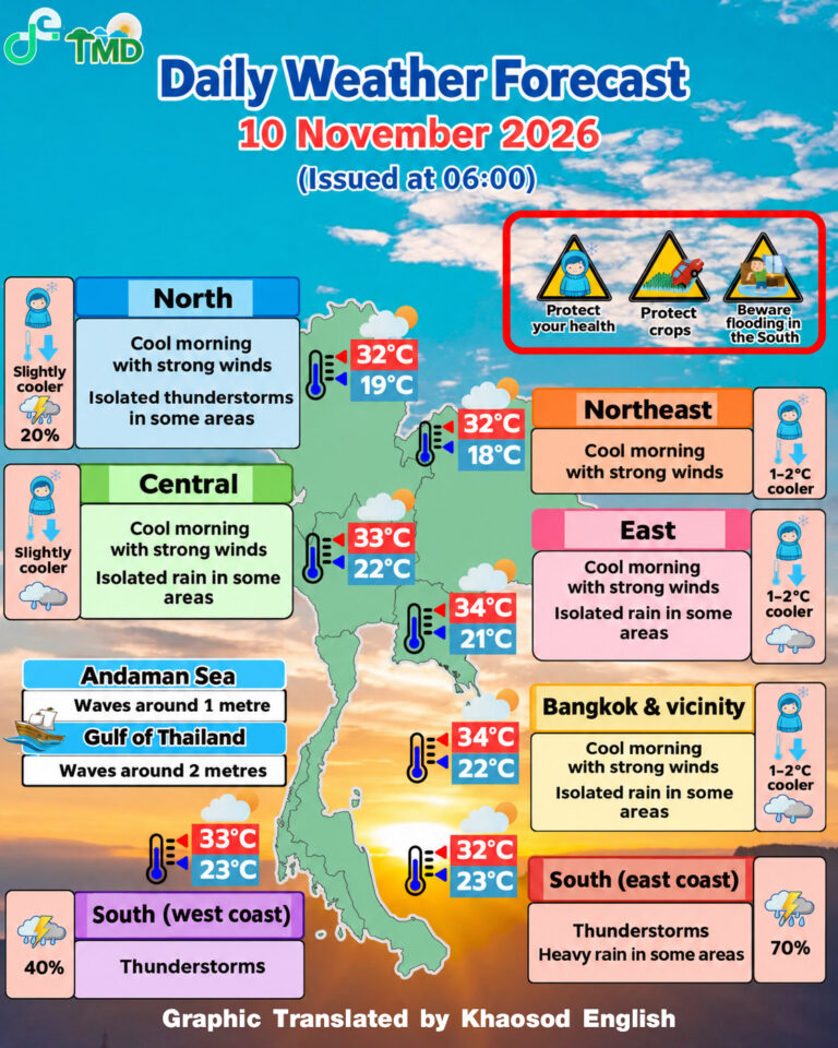
Forecast from 06:00 Tuesday to Wednesday
- North: Cool mornings and strong winds, with a slight temperature drop. Thunderstorms are expected across 20% of the region, with isolated gusts in Mae Hong Son, Chiang Mai and Chiang Rai. Lows of 19–23°C; highs of 28–32°C. Mountain peaks may fall to 9–15°C.
- Northeast: Cool mornings and strong winds, with temperatures falling by 1–2°C. Lows of 18–21°C; highs of 30–32°C. Mountain peaks may fall to 10–14°C.
- Central region: Cool mornings and strong winds, with a slight temperature drop and isolated light rain. Lows of 22–24°C; highs of 31–33°C.
- East: Cool mornings and strong winds, with temperatures falling by 1–2°C and isolated light rain. Lows of 21–23°C; highs of 31–34°C. Waves around one metre, rising above one metre offshore.
- Southern East Coast: Thunderstorms across 70% of the region, with isolated heavy rain in Chumphon, Surat Thani, Nakhon Si Thammarat, Phatthalung, Songkhla, Pattani, Yala and Narathiwat. Lows of 23–24°C; highs of 28–32°C. Waves of 1–2 metres north of Chumphon and around two metres from Surat Thani southwards, rising above two metres in thunderstorms.
- Southern West Coast: Thunderstorms across 40% of the region, mainly in Ranong, Phang Nga, Trang and Satun. Lows of 23–25°C; highs of 30–33°C. Waves around one metre, rising to around two metres offshore and above two metres in thunderstorms.
- Bangkok and surrounding provinces: Cool mornings and strong winds, with temperatures falling by 1–2°C. Isolated light rain is possible. Lows of 22–23°C; highs of 32–34°C.
KioskNews shows a cleaned-up reading view extracted from the publisher’s page — the original always lives on their site, not ours.