Small undersea volcanoes may unleash outsized tsunamis
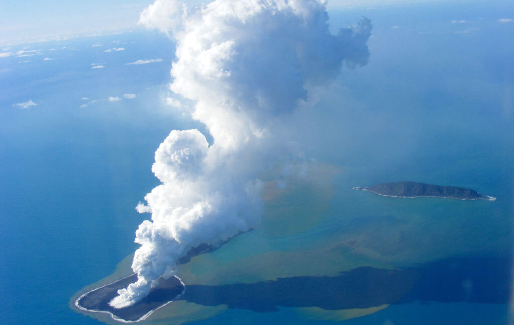
Krakatau, a volcanic island in Indonesia, killed more than 30,000 people when it erupted in 1883. One might assume that volcanic debris posed the major threat, yet many of the victims died from a tsunami caused by the volcanic eruption instead.
Volcanoes at sea can pose hazards quite different from those on land, as their impact can vary depending on how the volcanic activity interacts with seawater. In the deep ocean, high water pressure can suppress explosive volcanic activity, making eruptions less destructive. But closer to the surface, the lower water pressure and the high temperatures of volcanic material can cause violent explosions. Yet scientists still do not fully understand the conditions under which volcanic activity can cause a tsunami.
To better understand these risks, an international team of researchers examined the 2022 Hunga eruption in Tonga, focusing on the rapid caldera collapse that may have amplified its powerful tsunami. Calderas form when the ground above a magma reservoir collapses as the magma drains away. Comparisons of seafloor topography before and after the eruption showed that a roughly four-kilometer-wide caldera sank by about a kilometer during the eruption.
The researchers argue that the rapid collapse of the entire caldera may have enhanced the massive tsunami. Even a relatively small caldera like Hunga may be capable of producing a dangerous tsunami, depending on the speed and nature of its collapse. This suggests that other underwater volcanoes may also have the potential to generate dangerous tsunamis. Still, the paper warns that “The dynamics of submarine caldera-forming eruptions and, thus, the hazards they pose are not well understood, owing to the relative inaccessibility of the resulting calderas and eruption products.”
A roof too thin to hold
The Hunga volcano’s eruption on January 15, 2022, ranks among the most powerful volcanic events this century. The eruption column soared more than 55 km, pushing vaporized seawater up into the stratosphere, and the pressure wave from the explosion was detected across the globe. The accompanying tsunami is estimated to have reached heights of 40 meters within about 100 km from the source. It is the highest tsunami ever recorded from an underwater volcanic eruption.
For all its impact, Hunga’s caldera is quite small. The caldera left after the eruption is about four kilometers in diameter, making it one of the smallest of the 177 known calderas in a global database. What sets Hunga apart is that its caldera is unusually deep relative to its size. Relative to its diameter, the subsidence depth was comparable to that of famous calderas like Newberry in the United States.
The researchers suspect that the speed of the caldera collapse may have been one of the factors behind the massive tsunami. In general, when a submarine caldera collapses, the sinking seafloor pulls the seawater above it along with it. If the seafloor hundreds of meters below the surface drops abruptly, as it did at Hunga, a large volume of water can be displaced in a short time, potentially creating a tsunami.
In the paper, the team reconstructed how the collapse of the Hunga volcano unfolded. They compared a pre-eruption seafloor map made in 2015–2016 with post-eruption maps from five surveys conducted between April and October 2022.
The geometry of Hunga’s magma reservoir is considered one of the factors behind the rapid collapse. The reservoir’s roof was thin and broad, so it could barely support itself once the magma drained away. The reservoir lay about two kilometers beneath the volcano, shallow compared to its considerable width of four to five kilometers. The team calculated that the roof could cave in if reservoir pressure fell by only about 30 megapascals, roughly 300 times atmospheric pressure. That means losing just a quarter of the magma present pre-eruption would be enough to bring the roof down.
The Hunga caldera is thought to have collapsed even as the volcano was erupting. The sedimentary structures preserved beneath the caldera floor support this idea. A ship-based seismic survey conducted about three months after the eruption found that landslide deposits from the collapsing caldera walls were present below, within, and above the pyroclastic layers left by the eruption. The alternation of the two types of sediments suggests that debris from the broken walls was sliding down while pyroclastic material was still accumulating. If the caldera had collapsed after the eruption, the landslide deposits should lie on top of the pyroclastic layers.
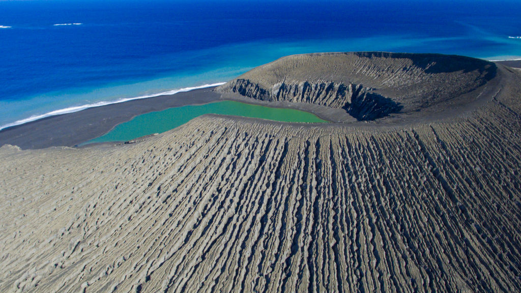
The pre-eruption Hunga volcano.
The pre-eruption Hunga volcano. Credit: Yves Gladu
The study found that the caldera sank by nearly one kilometer. Before the eruption, its floor lay 150 to 200 meters below sea level. Afterward, the caldera reached depths of up to 850 meters. Up to 150 meters of eruption-derived sediment covered the caldera floor, meaning the collapsed surface itself lies about 1,000 meters below sea level. The collapse of the caldera floor alone accounts for about 6.85 cubic km of volume.
One notable aspect of the Hunga collapse is the style in which it fell. Rather than breaking into pieces, the caldera floor maintained its shape as a whole, largely without bending.
The researchers identified the event as a “piston-style collapse,” so named because the floor drops the way a piston slides down a cylinder. The maps support this interpretation. The topography of Hunga shows distinct features along the eastern and southern walls of the caldera. A series of concentric terraces steps down toward the interior, separated by cliffs 100 to 150 meters high. These features are interpreted as evidence of faulting along the caldera rim as the floor subsided.
The researchers also suggest that faults associated with the sinking caldera may have allowed seawater to penetrate deep into the shallow magma reservoir, altering the eruption’s explosivity while promoting powerful underwater avalanches of volcanic debris
As the four-kilometer-wide caldera sank by a full kilometer, the water above would have been disturbed on a large scale. The researchers suspect the size of the tsunami was amplified by the way the caldera collapsed. They argue that even a small submarine caldera can produce dangerous waves under the right conditions.
The paper did not directly demonstrate that the caldera collapse produced the tsunami. Still, by tracing the collapse of a relatively small caldera that produced an unusually large tsunami, the study showed that rapid caldera subsidence is one of the possible factors that amplified the event. This suggests that even a relatively small submarine caldera could endanger nearby coasts, depending on the nature and speed of its collapse.
Dozens more volcanoes
The researchers caution that the risks extend beyond Hunga. Hunga belongs to the Tonga-Kermadec arc, which hosts at least 74 underwater volcanoes. Of these, 20 are caldera complexes. This means the region holds numerous underwater volcanoes under conditions that may be similar to Hunga’s. Nearby, the island volcano Tofua and the submarine volcano Fonuafoʻou both resemble Hunga in overall form, structure, magma composition, and even caldera size.
Yet most underwater calderas have never been surveyed as closely as Hunga. Their inaccessibility means many lack maps entirely, and others have only low-resolution data.
Hunga was a rare exception. It gained attention after a new island formed during an eruption in 2014–2015. A detailed seafloor map was created at the time, in 2015 and 2016. The researchers added land-surface data created using commercial satellite imagery and calibrated with NASA’s ICESat-2 laser altimetry to construct a 3D model of the whole of Hunga. This baseline made the before and after comparison possible. Without it, tracking the changes in the caldera would have been difficult.
The researchers called for detailed seafloor mapping to monitor underwater calderas. Such data would help track volcanic hazards and protect marine infrastructure.
The paper argues, “Our study underscores the urgent need for high-resolution repeat seafloor mapping,” which would help in “strengthening tsunami early-warning systems and protecting critical seafloor infrastructure, particularly in poorly surveyed regions such as the southwest Pacific.”
KioskNews shows a cleaned-up reading view extracted from the publisher’s page — the original always lives on their site, not ours.