Tropical threat brewing off Mexico could impact Gulf Coast this weekend
With less than two months remaining in the hurricane season, the potential for a ninth named tropical storm in the Atlantic basin is brewing in the southern Gulf.
Since the Atlantic's season began on June 1, it has only seen eight named storms this year, while El Niño continues to bring a more active season in the Pacific. The season ends Nov. 30.
What we know
Tropical Depression Nine formed in the Gulf on Tuesday, and a lot remains unknown as it brews over the warmer waters off Mexico in the Bay of Campeche.
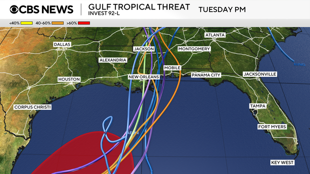
Forecast models are beginning to come to agreement that the northward motion of this tropical system brings it to the Gulf Coast this weekend.
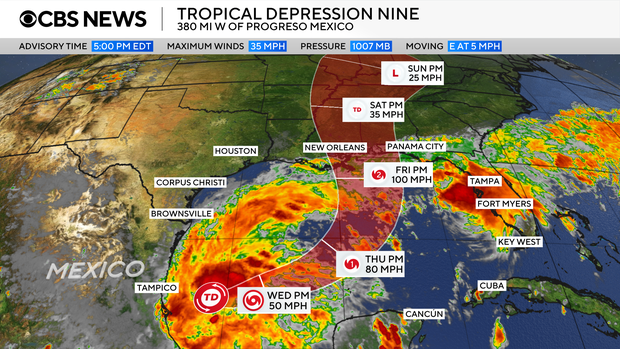
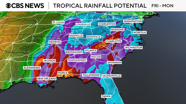
Regardless of its name or if it develops into a tropical storm, we do know that it will bring moderate to heavy rainfall to the Gulf Coast and into the rest of the Southeast this weekend into early next week.
Some longer-range forecast models also see this moisture eventually reaching the Ohio Valley and Northeast by midweek next week.
What we do not know
Timing, storm intensity and severity of impacts to land with this tropical system are what remain unknown.
While some models have impacts starting Friday evening, others show it beginning later in the weekend.
There is also some uncertainty regarding the system's storm intensity forecast, with some models keeping it as a tropical depression and others having it reach tropical storm strength. If it does become a tropical storm, it would receive the name Isaias, pronounced "ees-ah-EE-ahs."
Beware the "I"-named storm
While tropical storm and hurricane formation and frequency vary throughout the season, the "I"-named systems tend to be the most retired names within the Atlantic basin.
The most commonly known retired "I"-named storms are Ian (2022), Ida (2021), Irma (2017), and Irene (2011).
When Ike was retired in 2008, Isaias replaced the "I" name on the Atlantic tropical cyclones list, which rotates every six years.
KioskNews shows a cleaned-up reading view extracted from the publisher’s page — the original always lives on their site, not ours.