From jungle to oak forest: Hiking above Lake Chapala
Nature lovers who live on the shores of Lake Chapala are lucky indeed. All they have to do is step outside their door and start walking uphill. Within minutes, they will enter a network of around 100 kilometers (62 miles) of trails leading to scenic ridges and peaks. They truly live in a hiker’s paradise!
For an introduction to these trails, I recommend connecting with one of the already established hiking groups in the area. You can easily find them by contacting the Lake Chapala Society.
The Caracol Trail: From Africa to Canada?
One of the most fascinating lakeside hikes is to La Mesa del Ocote, the Mesa of the Old Pine Tree. The trail leading up to it is called Sendero El Caracol, the Snail Trail, because it includes a stretch of tight, continuous switchbacks that mimic the spiral of a snail’s shell, resulting in an altitude gain of 625 meters (2,050 feet).
The trailhead is located 3.3 kilometers (2 miles) north of the Chapala campus of the Tecnológico Superior de Jalisco.
The hike begins in a kind of jungle that practically swallows the narrow path you are following. On all sides, you hear birdsong as you brush past wild sage and maidenhair ferns. The trees above are thick with lichens, and the rocks below are carpeted with bright green moss.

‘Cuidado, hombre, you are still in Mexico’
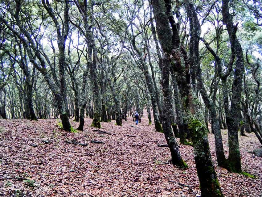
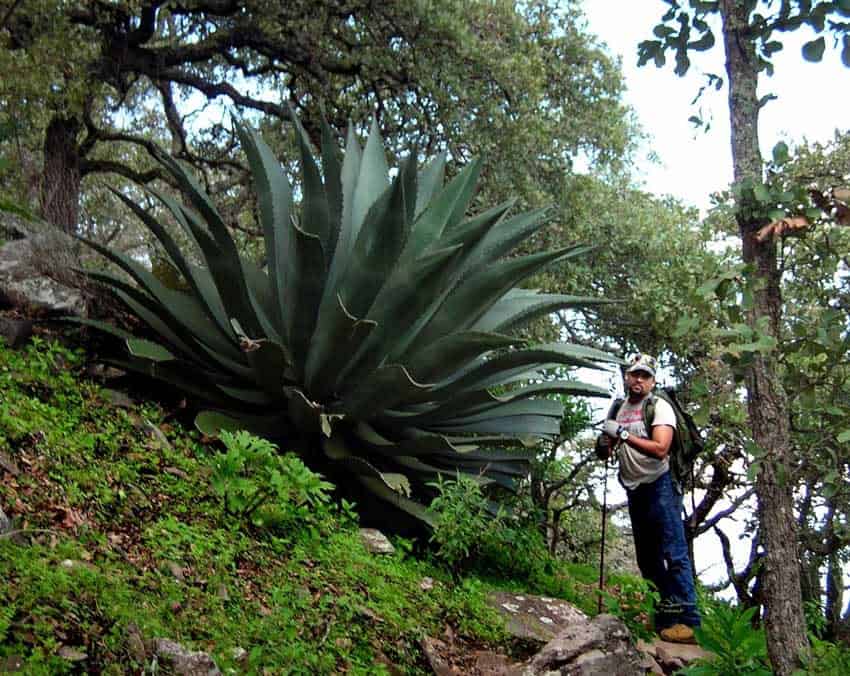
After 3 kilometers (1.8 miles), the Caracol switchbacks begin, and the jungle slowly gives way to rocky outcrops, which then, amazingly, transform into a forest of slender, straight oaks. Underneath them is a seemingly endless carpet of golden leaves, upon which no underbrush is growing. I’ve never seen woods like this elsewhere in Mexico: You are in a forest, but you can see forever in any direction. It’s as if you climbed out of Africa straight into Canada and then, when you are good and confused, you top a ridge and here’s a humongous agave 2 meters (6.5 feet) tall, which says, “Cuidado, hombre, you are still in Mexico.”
At last, you come to El Picacho, the peak, at an altitude of 2,447 meters (8,028 feet), where there is an antenna. From here, you have what some consider the very best view of Lake Chapala and the towns along its northern shore.
It could take you as little as 90 minutes to reach the top, but this timeframe can easily expand to four hours if you stop to take pictures.
The Indigenous Ceremonial Grounds via El Tepalo
This 5-kilometer (3-mile) hike begins at the north end of Hermenegildo Galeana Street in Ajijic and heads for a so-called waterfall called El Tepalo, where I keep hoping to glimpse water someday.
Along this trail, you will come upon “tourist trees” (Bursera simaruba), which appear red and peeling like many a tourist. These are commonly called papelillos in Spanish, so named for their smooth, thin, paper-like bark, which peels off in small curly strips.
Here you can also see an amate tree (strangler fig) sitting on a big rock. Amates often start as tiny seeds deposited on a tree branch. Amazingly, they are capable of sending a thin root all the way to the ground. Slowly, they grow around their host, eventually strangling it.
Once you are above the waterfall, check out the great view of the lake below you. And, by the way, don’t be surprised if you end up sharing one of these trails with a herd of cows.
La Danza del Sol
Next, you cross a saddle locally known as El Pandito.
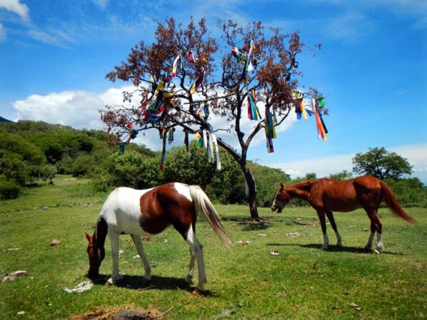
And, a mere 1.3 kilometers (0.8 miles) west of El Tepalo, as the blue mockingbird flies, you come to Danza del Sol. One minute you’re on a narrow trail beneath a canopy of creeping vines, and suddenly you step into a wide, flat, grassy meadow that takes your breath away. In the middle of it, there’s a lone tree festooned with long red, white, blue, green and yellow strips of cloth. The tree is surrounded by a very large circle of stones, and nearby, there are two buildings that serve to shelter and feed the many Indigenous people who come here from far and wide. Just outside the circle are two igloo-shaped frameworks made of thin branches. With the help of blankets, these are transformed into temazcales, or sweat lodges.
Here, for many years, Indigenous groups would gather for a piercing ritual known as La Danza del Sol, immortalized in the 1970 movie “A Man Called Horse.”
From the Ceremonial Grounds, you have a great view of the lake, and then a short, steep trail takes you back to Ajijic.
Trail guide in English
25 great hikes like these are described in the 140-page trail guide published in 2021 by Senderos de México in both Spanish and English versions. The guide has 100 color photos, as well as 26 maps featuring contour lines, estimates of hiking time and levels of difficulty.
Hanging bridge and Spanish moss
Curious about what lies south of Lake Chapala? How about a 350-meter-long (1,150-foot-long) hanging bridge over a deep gorge — or a river full of Montezuma cypresses festooned with more Spanish moss than a Louisiana bayou? You’ll find these and 98 more nearby sites for hiking and camping in the “Outdoors in Western Mexico” books, out of print but still available digitally. Happy trails!
John Pint has lived near Guadalajara, Jalisco, for more than 30 years and is the author of “A Guide to West Mexico’s Guachimontones and Surrounding Area” and co-author of “Outdoors in Western Mexico.” More of his writing can be found on his website.
KioskNews shows a cleaned-up reading view extracted from the publisher’s page — the original always lives on their site, not ours.