Anak Krakatau's land area expands to 341.5 hectares: PVMBG
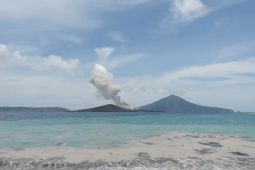
Bandung, W. Java (ANTARA) - Mount Anak Krakatau’s land area has expanded to 341.5 hectares following ongoing eruptions, surpassing its size prior to its catastrophic December 2018 collapse, according to official geological monitoring data.
Sentinel satellite imagery from Sept. 15 confirmed that volcanic deposits continuously expanded the Sunda Strait island beyond the 300 hectares recorded just days before the 2018 landslide and deadly tsunami.
The collapse of the volcano's southwestern flank drastically reduced its landmass to 246.18 hectares by late December 2018, according to the Center for Volcanology and Geological Hazard Mitigation (PVMBG).
"The collapse of the southwestern sector drastically reduced the mountain's land area to just 246.18 hectares by Dec. 26, 2018," PVMBG Head Rita Susilawati said in a statement on Saturday.
Continuous eruptive activity since then has allowed the volcanic structure to rebuild.
PVMBG recorded the area at 312.3 hectares on Aug. 8, before an additional 32.8 hectares of eruptive material deposited in early September brought the total to 341.5 hectares.
Joint research by Indonesia's National Research and Innovation Agency (BRIN) and international partners—including the University of Birmingham, Institut Teknologi Bandung, Penn State University, the British Geological Survey, and the University of Oxford—confirmed the volcano is in an active reconstruction phase.
BRIN researcher Dini Nurfiani noted that the 2018 collapse displaced roughly 0.116 cubic kilometers of material into the ocean, reducing the summit elevation from 330 meters to 120 meters.
While immediate post-collapse eruptions were explosive Surtseyan events triggered by seawater entering the crater, activity later transitioned between 2019 and 2026 to Strombolian lava fountaining and flows, steadily accumulating landmass.
However, scientists warn that the volcano’s regrowth remains structurally asymmetrical.
The southwestern flank is building over a steep underwater caldera slope, while the northeastern side sits on a shallower seabed. Dense lava layers piling atop light, porous ash deposits on uneven slopes continue to pose risks for long-term slope stability.
Translator: Ricky Prayoga, Yashinta Difa
Editor: Aditya Eko Sigit Wicaksono
Copyright © ANTARA 2026
KioskNews shows a cleaned-up reading view extracted from the publisher’s page — the original always lives on their site, not ours.