Isaias brings rain, wind and leaves thousands without power
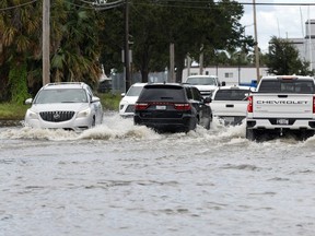
Downpours will spread across the U.S. South and Appalachians as Hurricane Isaias’ remnants head north after landing in Florida Friday night, knocking out power to hundreds of thousands of residents across three states.
Sign In or Create an Account
There’s a moderate risk of heavy rainfall across parts of western North Carolina south to Georgia Saturday, the US Weather Prediction Center said. The region was devastated by when Hurricane Helene swept through in 2024 — flooding cities, blocking roads, and killing at least 249 people nationallty.
Isaias shouldn’t bring the destructive force Helene unleashed, said Marc Chenard, a senior branch forecaster at the US Weather Prediction Center. “We still have to keep an eye on the southern Appalachians. It still looks like there could be some significant impacts there through the day.”

Get a dash of perspective along with the trending news of the day in a very readable format.
By signing up you consent to receive the above newsletter from Postmedia Network Inc.
A welcome email is on its way. If you don't see it, please check your junk folder.
The next issue of NP Posted will soon be in your inbox.
We encountered an issue signing you up. Please try again
Isaias will put about 12.6 million people from Florida to Virginia at a level two risk for severe thunderstorms, which can bring downpours and spawn tornadoes, through the weekend, the US Storm Prediction Center said.
The storm also hit energy production across the Gulf of Mexico during the week and knocked out power to more than 875,000 homes and businesses as of Saturday morning, according to PowerOutage.com.
Oil output in the Gulf of Mexico plummeted as the storm approached the US coast, companies evacuated crews from platforms as a precaution, and drillers sailed rigs out of its path.
The Category 2 storm made landfall at 8:30 p.m. near Destin, Florida, with top winds of 105 miles (169 kilometers) an hour. It quickly degraded into a post-tropical cyclone, according to the US National Hurricane Center.
The first hurricane to hit the US in almost two years will bring widespread rain of as much as 8 inches (20 centimeters) across the region, with as much as 15 inches seen in some localized areas.
Tropical storm conditions will likely continue Saturday morning as the storm system tracks north across Alabama and into the Tennessee and Ohio valleys throughout the day and into Sunday, forecasters said. The storm system is expected to bring heavy rain and could spawn tornadoes as far north as the Carolinas.
While the tropical risks subside in the east, western Mexico and the US Southwest face twin threats from Tropical Storm Rachel and Hurricane Simon.
Rachel is forecast to strike near the US-Mexico border in northern Baja California late Saturday and then bring flooding rains across the US Southwest, including parts of California, Arizona and Nevada, the US National Hurricane Center said.
There are rare tropical storm watches up across Southern California, including for San Diego.
Further south, Simon is forecast to strike near Manzanillo, Mexico, the country’s busiest Pacific port, overnight as Category 4 hurricane on the five-step, Saffir-Simpson scale, packing winds of 155 miles per hour. As much as 20 inches of rain may fall widely, with isolated spots getting up to 40 inches.
“Catastrophic wind and life-threatening storm surge impacts are likely along a portion of the west-central coast of Mexico,” the US hurricane center said. The rains “will produce life-threatening flooding and mudslides.”
Our website is the place for the latest breaking news, exclusive scoops, longreads and provocative commentary. Please bookmark nationalpost.com and sign up for our newsletters here.
Join the Conversation
This website uses cookies to personalize your content (including ads), and allows us to analyze our traffic. Read more about cookies here. By continuing to use our site, you agree to our Terms of Use and Privacy Policy.
KioskNews shows a cleaned-up reading view extracted from the publisher’s page — the original always lives on their site, not ours.