Tropical Depression Neneng downgraded to LPA, exits PAR; southwest monsoon weakens
Already have Rappler+?
to listen to groundbreaking journalism.
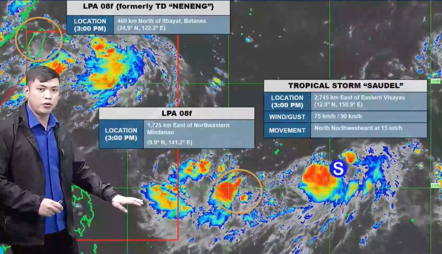
FORECAST. PAGASA Weather Specialist John Manalo explains the bureau's 5 pm forecast for the low pressure area that used to be Tropical Depression Neneng, a new LPA outside PAR, and Tropical Storm Saudel, also outside PAR, on August 20, 2026.
PAGASA
With Tropical Depression Neneng weakening into a low pressure area and moving farther away, the effects of the southwest monsoon also ease on Thursday, August 20
AT A GLANCE
- Tropical Depression Neneng weakened into a low pressure area and exited the Philippine Area of Responsibility on Thursday, August 20.
- Luzon is seeing improved weather as the southwest monsoon has weakened.
- PAGASA is still monitoring Tropical Storm Saudel outside the Philippine Area of Responsibility, as well as a new LPA outside PAR.
This is AI-generated. Read the article for full context. Report any errors.
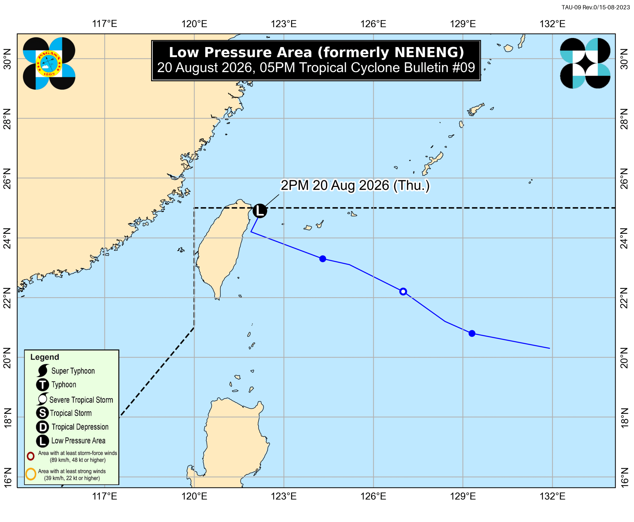
MANILA, Philippines – Tropical Depression Neneng weakened into a low pressure area (LPA) at 2 pm on Thursday, August 20, then exited the Philippine Area of Responsibility (PAR).
As of 4 pm, the LPA that used to be Neneng was already 480 kilometers north of Itbayat, Batanes.
The Philippine Atmospheric, Geophysical, and Astronomical Services Administration (PAGASA) said in its 5 pm bulletin that the LPA or remnant low will head for the East China Sea.
PAGASA added that “the possibility of redevelopment into a tropical depression within the coming days is not ruled out,” as current conditions are favorable for the remnant low to regain strength.
As a tropical depression, Neneng’s maximum sustained winds had peaked at just 55 kilometers per hour (km/h). It also stayed far from Philippine landmass, and had no direct impact on the country.
However, it enhanced the southwest monsoon or habagat in the past couple of days, after developing last Tuesday, August 18.
Neneng was the Philippines’ 14th tropical cyclone for 2026, and the third tropical cyclone for August, after Tropical Depression Luis and Tropical Storm Maymay (Kujira).
With Neneng weakening into an LPA and moving farther away, the effects of the southwest monsoon also eased starting Thursday.
By 11 am, PAGASA said significant rainfall was no longer expected from the southwest monsoon. The weather bureau’s 4 pm forecast, meanwhile, shows the Ilocos Region, Batanes, Cagayan, and Apayao may just have scattered rain and thunderstorms due to the southwest monsoon in the next 12 hours, while the rest of Luzon will have generally fair weather with just isolated rain showers or thunderstorms.
From Thursday to Saturday, August 22, the southwest monsoon will also bring strong to gale-force gusts to most of Luzon, most of the Visayas, the Davao Region, Northern Mindanao, and Zamboanga del Norte.
Moderate to rough conditions will also persist in several seaboards on Thursday.
Up to rough seas (small vessels should not venture out to sea)
- Western seaboards of Batanes and Babuyan Islands – waves up to 4 meters high
- Seaboards of Ilocos Norte; remaining seaboards of Batanes – waves up to 3.5 meters high
- Seaboards of Ilocos Sur and Zambales; western seaboard of Pangasinan; northwestern seaboard of Kalayaan Islands – waves up to 3 meters high
Up to moderate seas (small vessels should take precautionary measures or avoid sailing, if possible)
- Seaboards of La Union and Lubang Islands; northern seaboard of Pangasinan; western seaboard of Batangas; western and southern seaboards of Bataan – waves up to 2.5 meters high
- Western seaboard of Occidental Mindoro; northern and western seaboards of northern Palawan including Calamian Islands; remaining seaboards of Babuyan Islands and Kalayaan Islands – waves up to 2 meters high
ALSO ON RAPPLER
- PNP: 74 cases linked to nihilistic violent extremism, 42 minors rescued so far
- Guteza withdraws allegations vs Romualdez, dealing blow to Ombudsman complaint
- Mikee Romero retires from AFP Reserve Force amid medals controversy
PAGASA also provided updates on the weather systems outside PAR.
First, the tropical depression that developed over the West Philippine Sea last Tuesday already left PAGASA’s Tropical Cyclone Information Domain as of 8 am on Thursday. This means the weather bureau is no longer monitoring or providing information on this particular tropical cyclone.
Second, PAGASA continues to monitor the tropical storm with the international name Saudel. As of 3 pm on Thursday, Saudel was located 2,745 kilometers east of Eastern Visayas, moving north northwest at 15 km/h. It still has maximum sustained winds of 75 km/h and gustiness of up to 90 km/h.
PAGASA Weather Specialist John Manalo said Saudel could enter the northeastern corner of PAR on Sunday, August 23, or Monday, August 24, and start enhancing the southwest monsoon. For now, there is still high uncertainty in the forecast for the tropical storm since it remains far from PAR.
Third, the weather bureau announced on Thursday afternoon that an LPA has formed outside PAR. It was located 1,725 kilometers east of northeastern Mindanao as of 3 pm.
The LPA has a medium chance of developing into a tropical depression within 24 hours, but it may eventually just dissipate outside PAR, according to Manalo.
PAGASA previously estimated that up to four tropical cyclones may develop within or enter PAR in August. The next tropical cyclone name on the weather bureau’s list is Obet. – Rappler.com
KioskNews shows a cleaned-up reading view extracted from the publisher’s page — the original always lives on their site, not ours.