EQUAL EARTH OP-ED: Scale of justice: Redrawn world map finally reflects Africa’s rightful size
As an African, growing up in a township while attending school in the 1990s, the world was delivered to us on pull-down wall maps and heavily creased geography, history and social studies textbooks. We sat on wooden benches, copying dates from a blackboard, absorbing a systematic falsehood: that Africa was small, peripheral, waiting to be found.
We were taught that a Scottish missionary named David Livingstone discovered Mosi-oa-Tunya, the roaring sheet of falling water our ancestors had lived beside for generations, and renamed it Victoria Falls – in honour of Queen Victoria. History arrived as a sequence of European sightings. A more honest sentence exists, and it is barely longer: Livingstone was the first recorded European to see the falls, in 1855, and afterwards named them for his queen. That single insertion, “first recorded European”, changes the whole philosophy of the story. It does not erase what Livingstone did. It simply stops pretending that meaningful human knowledge of a place begins the moment a European writes it down.
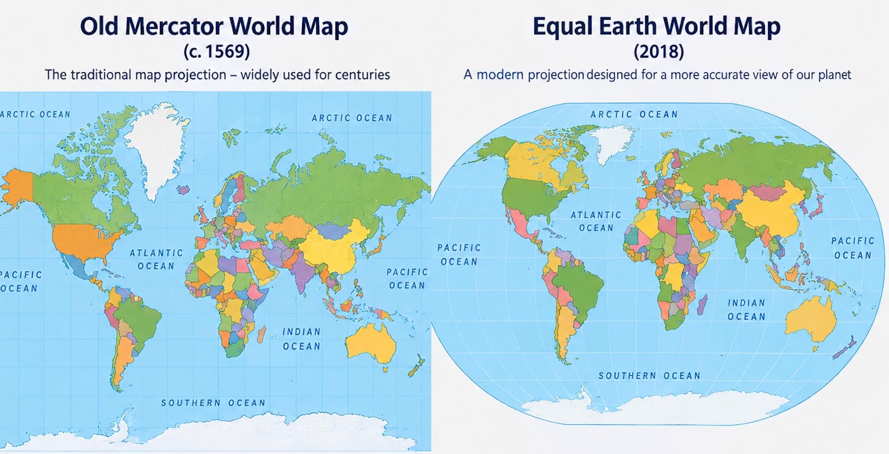
The erasure was spatial too. Hanging in every geography class was Gerardus Mercator’s 1569 projection. We stared at the map for hours during exams, absorbing its message without being told it was a message. Greenland swelled to the size of our entire continent. Europe sat vast and central; Africa was squashed at the equator. No one mentioned that Mercator built the map as a 16th-century sailing tool to preserve compass bearings for European ships, and that this came at the cost of grossly inflating landmass near the poles. To a child, that distortion did real work. It taught us to see our home as a footnote, dependent on the validation of the oversized nations above it.
On 4 September 2026, the UN General Assembly voted 164 to one, with six abstentions, to endorse the Equal Earth projection over Mercator for general world maps. The US cast the lone dissenting vote, its delegate arguing that the institution was wasting its time on “map projects from the 16th century” instead of, in her words, genuine problems. The resolution’s own text described the correction as an act of cognitive justice and memorial reparation. The African Union had already said as much more plainly still: at its own summit earlier this year it adopted Equal Earth as continental policy and located the decision explicitly within “cognitive justice and reparations”, tying a map projection to Africa’s right to narrate itself.
There is a bitter footnote to the American vote. Five weeks before it was cast, the US State Department displayed a map at a health conference in Rio de Janeiro that mislabelled every African country it named: Nigeria shown landlocked in the Sahara, Mozambique relocated to the Horn of Africa, Côte d’Ivoire moved to the opposite coast.
The department later traced the image to an AI tool and took, in its own words, “full responsibility”. It is not evidence of a conspiracy against Africa. It is something more ordinary and, in its way, more revealing: even the government objecting loudest to the idea that African geography deserves careful attention could not, weeks earlier, be bothered to place Nigeria on the correct side of the continent.
The map’s distortion was never the whole story, only the visible layer of it. When European prospectors encountered the mortarless stone towers of Great Zimbabwe, they refused to credit indigenous Africans with building them, inventing myths that traced the architecture to King Solomon or Phoenician traders. Colonial historiography shrank African historical agency the way Mercator shrank African landmass, insisting the continent could not have engineered or planned a city without outside help. The several hundred thousand manuscripts on astronomy, law and mathematics housed in Timbuktu were set aside to preserve the story that literacy, too, had arrived from elsewhere.
That erasure became infrastructure. We were taught that colonialism brought civilisation via roads and railways. A logistics map tells a different story: colonial railways ran in short, direct lines from inland mines and plantations to coastal ports, built to move resources out rather than to connect African communities to one another. It was engineering for extraction, and it left behind fragmented internal economies the continent is still working to knit together.
It culminated in 1884-85, when European powers sat in Berlin with straight edges and pens and divided a continent with no African representative in the room, treating a populated, complex landmass as empty ground, drawing lines through unified societies and forcing rival polities into shared administrative cages.
None of this means a corrected map will repay a country’s debt or build a hospital. Africa’s underdevelopment is the product of extractive trade structures, colonial borders, weak institutions and, in places, its own governments, not of a projection invented in Antwerp. But the reverse claim is just as lazy: that representation is trivial because it changes no balance sheet. A continent should not have to choose between material justice and the right to be drawn at its actual size. Debt relief and an honest atlas are not competing demands.
Africa covers roughly 30 million square kilometres, large enough to hold the US, China, India and most of Europe within its coastline at once. It was always that big. What is changing is not the continent but the world’s willingness to say so, in a chamber where, for once, the description was written by the people being described. Redrawing the map is a win. Filling the space it reveals – in the textbooks and curriculums that taught generations of us where to stand while looking at the world – is the work still ahead. DM
KioskNews shows a cleaned-up reading view extracted from the publisher’s page — the original always lives on their site, not ours.