UN votes to adopt new world map that shows Africa’s true scale 聯合國表決採用新世界地圖 真實呈現非洲面積
The UN has voted to adopt a resolution for the world to formally phase out the traditional Mercator map of the globe in favor of one that more accurately displays Africa’s size.
In a session at its headquarters in New York, the UN general assembly officially retired the 16th-century Mercator projection in favor of one based on the more accurate 2018 Equal Earth design.
At the session, 164 countries voted in favor of the resolution. Only the US voted against it while six other countries — Serbia, Estonia, Georgia, Lithuania, Moldova and Ukraine — abstained.
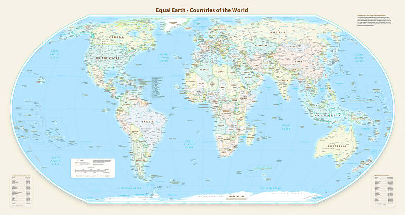
This handout graphic provided by Equal Earth shows the Equal Earth cartographic projection. 以「平等地球投影」所繪製的地圖。Equal Earth提供。
Photo: AFP 照片:法新社
UN resolutions are non-enforceable, so countries and institutions will not be mandated to use only the new projection or forbidden from using the old one. However, the outcome is expected to result in an update of classroom curriculums and everyday technology given the wide usage of the Mercator projection in education, technology and governance.
Togo, which spearheaded a campaign for the resolution on behalf of the African Union (AU), said the resolution “recognizes and affirms that disproportionate cartographic representations, particularly those resulting from the Mercator projection, have had lasting cognitive, educational, cultural, geopolitical and socioeconomic effects, contributing to a drastic reduction in the perceived size of Africa and other regions of the world in the global collective imagination.”
Speaking before the resolution passed, Robert Dussey, Togo’s foreign affairs minister, said: “This discussion is not a political discussion [but] a scientific discussion, because there is scientific proof so we all have to accept the reality.”
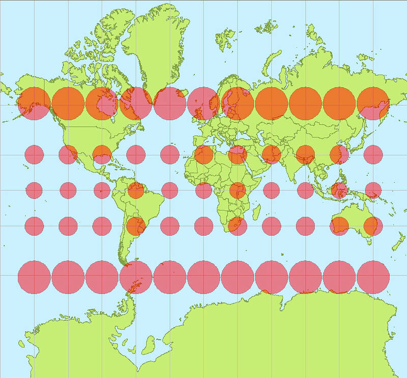
A Mercator projection map with Tissot’s indicatrices (a mathematical and graphical tool used in cartography to visualize and quantify the distortion caused by map projections). 麥卡托投影法地圖,用底索指示線(又稱變形橢圓,製圖學中用來視覺化與衡量地圖投影失真的數學工具)可看出其失真程度。
Photo: Stefan Kühn /Wikimedia Commons 照片:Stefan Kühn∕維基共享資源
The Mercator layout was introduced by the Flemish cartographer Gerardus Mercator in 1569 to help sailors navigate the seas. Almost five centuries later, it remains the global standard.
Because of its projection style, however, regions near the equator appear significantly smaller than they are, whereas high-latitude areas look much larger. For example, the map shows Africa as being similar in size to Greenland, but the continent is 14 times larger than the Danish territory.
“You could fit the United States, China, India, Japan, Mexico and much of Europe into Africa and still have land to spare,” says a petition on Change.org for the #CorrectTheMap campaign, which has more than 11,000 signatures. The AU endorsed the campaign in August of last year and then asked Togo to spearhead its adoption.
On Sept. 4, before the vote, France’s foreign minister Jean-Noel Barrot spoke in support of the resolution. “[We] will abandon the Mercator projection in favor of map representations tailored to specific uses, more faithful to actual surface areas and in line with the recommendations of cartographers and scientists,” Barrot said during a speech at the Sorbonne University in Paris, in a move seen as part of France’s push to increase goodwill among its former colonies. France will now use the Eckert IV projection, which is close to the Equal Earth projection recommended in the resolution.
Historians and geographers have said for years that the Mercator projection is rooted in western stereotypes. Activists have echoed this, with some coining the term “cartographic colonialism.”
Some argue that the map has subtly shaped international power dynamics by minimizing the physical presence of the global south and visually inflating northern hemisphere nations while shrinking equatorial regions. This is said to have reinforced systemic biases in international trade, development priorities and educational frameworks.
One of the Mercator projection’s most prominent critics was Arno Peters, a German historian, who launched the Peters world map based on the Gall–Peters projection in 1973. It has often been used as an alternative to the Mercator map.
Togo’s #CorrectTheMap campaign promoted the use of the 2018 Equal Earth design, which was developed by an international team of cartographers. Supporters say it will help to reverse perceptions of Africa and decolonize global curriculums.
(The Guardian)
聯合國通過一項決議,正式支持全球逐步淘汰以「麥卡托投影法」(Mercator projection)製作的傳統世界地圖,改用能更準確呈現非洲實際面積的地圖投影法。
聯合國大會在紐約總部舉行會議,正式支持以2018年推出、準確度更高的「平等地球投影」(Equal Earth projection)為基礎的地圖,取代16世紀的麥卡托投影。
這項表決有164個國家投下贊成票。只有美國投下反對票,另外有6個國家——塞爾維亞、愛沙尼亞、喬治亞、立陶宛、摩爾多瓦與烏克蘭——棄權。
聯合國決議並不具法律強制力,因此各國及各機構不會被強制要求只能使用新投影法,也不會被禁止繼續使用舊地圖。不過,由於麥卡托投影法長期廣泛應用於教育、科技與政府治理,此次決議預料將促使學校課程及日常科技產品逐步更新。
代表「非洲聯盟」(African Union)推動這項決議的多哥表示,這項決議「承認並闡明,不成比例的地圖呈現方式,尤其是麥卡托投影法所造成的結果,已造成長久的認知、教育、文化、地緣政治與社會經濟影響,使非洲及世界其他地區的實際大小在全球集體想像中遭到大幅縮減」。
在決議通過前,多哥外交部長羅伯特.杜西表示:「這不是政治問題,而是科學問題,因為有科學證據,所以我們都必須接受這個事實」。
1569年,佛蘭芒製圖師格拉杜斯.麥卡托發明了麥卡托投影法,原本是為了協助水手在海上航行。近五個世紀過去了,它仍然是全球標準。
然而,由於這種投影方式的特性,靠近赤道的地區在地圖上會顯得比實際面積小得多,而高緯度地區則會被大幅放大。例如,麥卡托地圖上的非洲看起來跟格陵蘭島差不多大,但實際上,非洲大陸的面積是格陵蘭這丹麥自治領地的14倍。
線上公眾請願與連署平台Change.org上一份支持#CorrectTheMap(修正地圖)運動的請願書指出:「你可以把美國、中國、印度、日本、墨西哥,以及歐洲大部分地區都放進非洲這塊土地,還有得剩」。這份請願書目前已有超過1.1萬人連署。非洲聯盟在2025年8月正式支持這項運動,並要求多哥帶頭推動各國採用新的地圖投影法。
在9月4日表決前,法國外交部長也發言支持這項決議。法國外長尚.諾埃爾.巴羅在巴黎索邦大學演講時表示:「我們將放棄麥卡托投影法,改用依不同用途設計的地圖呈現方式;這些方式更忠於實際地表面積,也符合製圖師與科學家的建議」。外界認為,此舉也是法國試圖向其前殖民地釋出善意、改進關係的一環。法國之後將採用艾克特第四投影法(Eckert IV projection),其特性與決議中推薦的等積地球投影相近。
歷史學家與地理學家多年來不斷指出,麥卡托投影法帶有西方中心主義的歷史與刻板印象。社運人士也提出類似批評,有人還提出了「地圖學殖民主義」(cartographic colonialism)一詞。
部分學者認為,麥卡托投影地圖在不知不覺間形塑了國際權力關係:它縮小了全球南方在視覺上的存在感,卻放大了北半球國家的視覺比例,同時縮小赤道地區。這種視覺上的偏差,被認為進一步強化了國際貿易、發展政策優先順序及教育體系中的結構性偏見。
麥卡托投影法最著名的批評者之一,是德國歷史學家阿諾.彼得斯。他在1973年推出以高爾—彼德斯投影法(Gall–Peters projection)為基礎的彼得斯世界地圖,被視為麥卡托地圖的一種替代方案。
多哥主導的#CorrectTheMap運動則推廣2018年推出的「平等地球投影」。這套設計由一支國際製圖師團隊共同開發。支持者認為,新投影法有助於扭轉人們對非洲的既有認知,並推動全球教育課程的去殖民化。
KioskNews shows a cleaned-up reading view extracted from the publisher’s page — the original always lives on their site, not ours.