Heavy rain expected in parts of Metro Manila, Luzon Tuesday afternoon
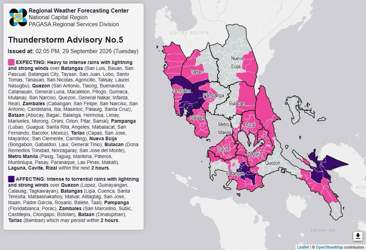




MANILA, Philippines — The state weather bureau warned that heavy to intense rains may prevail over parts of Metro Manila and Luzon on Tuesday afternoon, Sept. 29, due to localized thunderstorms.
In a thunderstorm advisory issued at 2:05 p.m., the Philippine Atmospheric, Geophysical and Astronomical Services Administration (Pagasa) said that heavy to intense rains with lightning and strong winds may affect the following areas within the next two hours.
- Cavite
- Laguna
- Rizal
- Metro Manila (Pasig, Taguig, Marikina, Pateros, Muntinlupa, Pasay, Paranaque, Las Pinas, and Makati)
- Nueva Ecija (Bongabon, Gabaldon, Laur, and General Tinio)
- Bataan (Abucay, Bagac, Balanga, Hermosa, Limay, Mariveles, Morong, Orani, Orion, Pilar, and Samal)
- Batangas (San Luis, Bauan, San Pascual, Batangas City, Taysan, San Juan, Lobo, Santo Tomas, Tanauan, San Nicolas, Agoncillo, Talisay, Laurel, and Nasugbu)
- Bulacan (Dona Remedios Trinidad, Norzagaray, and San Jose del Monte)
- Pampanga (Lubao, Guagua, Santa Rita, Angeles, Mabalacat, San Fernando, Bacolor, and Mexico)
- Quezon (San Antonio, Tiaong, Buenavista, Catanauan, General Luna, Macalelon, Pitogo, Gumaca, Mulanay, San Narciso, Quezon, General Nakar, Infanta, and Real)
- Tarlac (Capas, San Jose, Mayantoc, San Clemente, and Camiling)
- Zambales (Cabangan, San Felipe, San Narciso, San Antonio, Candelaria, Iba, Masinloc, Palauig, and Santa Cruz)
Meanwhile, intense to torrential rains are already affecting areas listed below, and may prevail in the next two hours.
Article continues after this advertisement
- Bataan (Dinalupihan)
- Batangas (Lipa, Cuenca, Santa Teresita, Mataas na kahoy, Malvar, Alitagtag, San Jose, Ibaan, Padre Garcia, Rosario, Balete, and Taal)
- Pampanga (Floridablanca and Porac)
- Quezon (Lopez, Guinayangan, Calauag, and Tagkawayan)
- Tarlac (Bamban)
- Zambales (San Marcelino, Subic, Castillejos, Olongapo, and Botolan)
READ: ITCZ to bring rains over Palawan, parts of Visayas, Mindanao Tuesday
Pagasa, in its 5 a.m. weather advisory said that that Metro Manila and the rest of Luzon may experience partly cloudy to cloudy skies with chances of localized thunderstorms on Tuesday. /gsg
Your subscription could not be saved. Please try again.
Your subscription has been successful.
READ NEXT
EDITORS' PICK
MOST READ
Disclaimer: Comments do not represent the views of INQUIRER.net. We reserve the right to exclude comments which are inconsistent with our editorial standards. FULL DISCLAIMER
© Copyright 1997-2026 INQUIRER.net | All Rights Reserved
NewsHub
New
Visayan Electric joins Sapangdaku community in growing Cebu A-Park’s green legacy
KioskNews shows a cleaned-up reading view extracted from the publisher’s page — the original always lives on their site, not ours.