Saudel intensifies into severe tropical storm outside PAR
Already have Rappler+?
to listen to groundbreaking journalism.
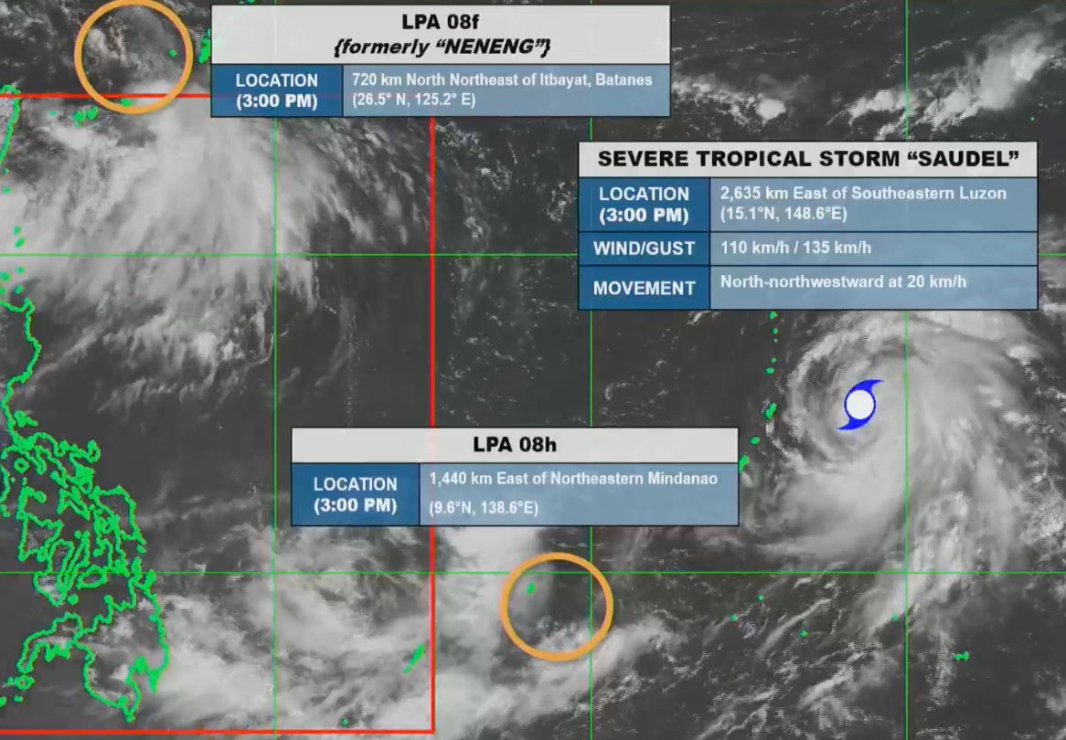
WEATHER SYSTEMS. Satellite image of Severe Tropical Storm Saudel and two low pressure areas outside the Philippine Area of Responsibility as of August 21, 2026, 3 pm.
PAGASA
PAGASA continues to monitor the tropical cyclone with the international name Saudel, which remains outside the Philippine Area of Responsibility
AT A GLANCE
- Saudel intensified into a severe tropical storm outside the Philippine Area of Responsibility on Friday, August 21.
- Landfall appears unlikely in the Philippines, but Saudel is seen to eventually enhance the southwest monsoon.
This is AI-generated. Read the article for full context. Report any errors.
MANILA, Philippines – Saudel, the tropical cyclone being monitored outside the Philippine Area of Responsibility (PAR), intensified from a tropical storm into a severe tropical storm on Friday, August 21.
By Friday afternoon, Saudel’s maximum sustained winds had already reached 110 kilometers per hour, with gustiness of up to 135 km/h.
The severe tropical storm was last spotted 2,635 kilometers east of southeastern Luzon at 3 pm on Friday, moving north northwest at 20 km/h.
The Philippine Atmospheric, Geophysical, and Astronomical Services Administration (PAGASA) said Saudel could enter PAR by Monday, August 24. If it enters PAR, it would be given the local name Obet.
The potential Obet might head for Okinawa, Japan, according to PAGASA Weather Specialist Benison Estareja. This means it is less likely to make landfall in the Philippines.
However, the tropical cyclone could enhance the southwest monsoon or habagat, which may again trigger significant rainfall in Luzon and Western Visayas in the last week of August.
Since Thursday, August 20, Luzon and Western Visayas have seen generally better weather as the southwest monsoon finally weakened after days of moderate to intense rain.
On Friday, the southwest monsoon is only causing scattered rain and thunderstorms in the Ilocos Region, Apayao, Abra, Benguet, Batanes, and Cagayan, as well as isolated rain showers or thunderstorms in the rest of the Cordillera Administrative Region, the rest of Cagayan Valley, Central Luzon, Metro Manila, and Calabarzon.
Starting Sunday, August 23, the southwest monsoon may gradually strengthen because of the approaching Saudel. Estareja said portions of Luzon might first have generally light to moderate rain, with periods of heavy rain, on Sunday and Monday.
By Tuesday, August 25, more areas could be affected. PAGASA advised the public to monitor updates, especially possible rainfall warnings.
Meanwhile, the weather bureau continues to monitor two low pressure areas (LPAs) outside PAR, although they do not pose a threat to any part of the country.
The LPA that used to be Tropical Depression Neneng was located 720 kilometers north northeast of Itbayat, Batanes, as of 3 pm on Friday. It has a medium chance of redevelopment into a tropical cyclone.
Neneng had been downgraded to an LPA and left PAR on Thursday.
The other LPA, last spotted 1,440 kilometers east of northeastern Mindanao, also has a medium chance of developing into a tropical cyclone. But it is unlikely to enter PAR and may just dissipate outside.
PAGASA previously estimated that up to four tropical cyclones may develop within or enter PAR in August. So far, there have been three during the month: Tropical Depression Luis, Tropical Storm Maymay (Kujira), and Neneng. – Rappler.com
KioskNews shows a cleaned-up reading view extracted from the publisher’s page — the original always lives on their site, not ours.