The Pacific is churning with hurricanes. The Atlantic is quiet. Blame El Niño
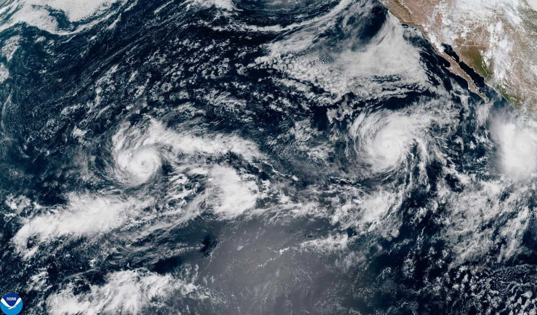
This satellite image from the National Oceanic and Atmospheric Administration shows three storms in the Pacific Ocean on Thursday, Sept. 24, 2026. Tropical Storm Nolo, left, is south of Hawaii. Hurricane Polo, right, is off the coast of Mexico. Hurricane Odalys is in the middle.
NOAA via AP/NOAA
hide caption
toggle caption
NOAA via AP/NOAA
It's been an extreme hurricane season in both the Atlantic and Pacific Oceans — but for vastly different reasons.
The Pacific Ocean has seen 18 hurricanes so far and 41 named storms overall, which are unusually high numbers for this point in the season.
The Atlantic Ocean is experiencing the exact opposite.
For the first time in over 100 years, no full-blown hurricanes have formed in the Atlantic as of September 25. Only seven named storms have formed, all of which were less-intense tropical storms.
"It's a tale of two basins," says Gabriel Vecchi, a professor of geosciences at Princeton University. "The Pacific: incredibly active. The North Atlantic: incredibly inactive."
Scientists say this is likely due to a powerful El Niño climate pattern. This natural pattern, which occurs every few years, tends to suppress hurricanes in the Atlantic while fueling more storms in the Pacific.
Hawaii is one place bearing the brunt of this shift.
Hurricane Nolo is expected to bring heavy rainfall and potential flooding to Hawaii this weekend, according to the National Hurricane Center.
It's the third hurricane to threaten the islands this year, following Hurricane Lala in August and Hurricane Lowell in early September.

Ryanna Fry takes a picture of clouds as Hurricane Nolo sits nearby in Kona, Hawaii, Friday, Sept. 25, 2026. Gregory Bull/AP hide caption
toggle caption
Gregory Bull/AP
The role of El Niño
Why is it such an unusual year? Climate scientists point to this year's record-breaking El Niño.
El Niño happens when water temperatures increase in the Pacific Ocean, near the equator. That warmer water provides fuel for hurricanes, driving bigger and more powerful storms. That means when a storm forms, it's more likely to reach hurricane strength.
It also affects weather patterns around the globe. In the North Atlantic, El Niño tends to increase wind shear, making it more difficult for hurricanes to form by tearing storms apart.
This year, El Niño is more intense than usual. Pacific water temperatures are already hitting record highs, even though the phenomenon won't reach its peak until later this year.
"We are headed toward what will almost certainly be the strongest El Niño on record," says Brian McNoldy, a senior research associate at the University of Miami. "It has exceeded expectations," in both the Pacific and the Atlantic, he says.
Warmer waters can also fuel more rapid intensification once storms form.
On Tuesday, Hurricane Polo, off Mexico's Pacific coast, strengthened from a tropical storm to a Category 5 hurricane in less than 24 hours.
Vecchi describes the intensification of Polo as "astounding."
Such rapid intensification can make storms more dangerous, in part by limiting the time people have to prepare.
What is the role of climate change?
Scientists are still trying to understand why some El Niño events are stronger than others. Some recent studies suggest climate change may be driving stronger El Niño events.
That science remains uncertain, Vecchi says, but the potential impacts of El Niño are well-understood.
El Niño generally raises temperatures globally and can make some areas around the world wetter and others drier.
In the immediate future, Paul Roundy, a professor of atmospheric science at the University at Albany, says he's watching for more storms to impact Hawaii along with droughts and fires in Central America.
El Niño could also bring a wetter winter for parts of the Southwestern U.S., where drought has persisted. But this could also increase the risk of floods.
These impacts from El Niño come on top of warming driven by human-caused climate change, which is already increasing the likelihood of extreme weather around the world.
"You can think of climate change as always acting in the background of basically everything we're experiencing in the ocean, in the atmosphere," McNoldy says. "So it tips the scales."
KioskNews shows a cleaned-up reading view extracted from the publisher’s page — the original always lives on their site, not ours.