NASA captures nighttime image of Cyclone Arnab two days before it battered Andhra Pradesh
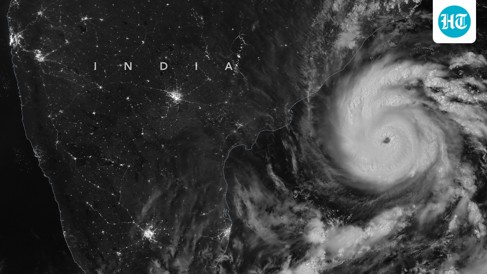
Cyclone Arnab left parts of the Andhra Pradesh coast battered after bringing strong winds and heavy rain. Amid the storm's passage, NASA's satellite captured a nighttime image of Cyclone Arnab as it moved across the Bay of Bengal. The image was captured two days before the landfall.
According to the India Meteorological Department (IMD), the storm sustained with winds of around 140 kilometres per hour.
Cyclone Arnab, the first named storm of the 2026 North Indian Ocean cyclone season, emerged over the Bay of Bengal on October 25. Its arrival came relatively late in the season, as named cyclones in the region typically begin forming in April or May.
Also read: Cyclone Arnab caused ₹4,600 crore worth of losses in Andhra Pradesh: CM Naidu
Satellite captures storm over the Bay of Bengal
The nighttime image was captured by the Visible Infrared Imaging Radiometer Suite (VIIRS) aboard NOAA-20 at 1:42 am Indian Standard Time on October 27.
At the time, the storm had sustained winds of approximately 140 kmph. The satellite image showed Arnab as it continued moving towards the Indian coast.
The storm later made landfall early on October 28, between Bapatla and Visakhapatnam along the Andhra Pradesh and Yanam coast. Its sustained wind speed at the time was around 130 kmph.
The IMD classified Arnab as a very severe cyclonic storm. Its wind strength was comparable to a Category 1 storm on the Saffir-Simpson hurricane wind scale.
Arnab causes damage across coastal areas
Cyclone Arnab affected the coastal regions of Andhra Pradesh and Odisha, including large cities, agricultural land, and fishing communities.
The cyclone caused widespread damage, including uprooted trees, flooded homes and inundated agricultural fields. Fishing activities were restricted, while transport and electricity networks faced disruptions.
Indian authorities evacuated more than 10,000 people from vulnerable coastal areas as a precaution.
Also read: Heavy rain warning in Chhattisgarh post-Cyclone Arnab; schools shut in Raipur.
El Niño and cyclone activity in the Bay of Bengal
Cyclone Arnab developed during the ongoing El Niño period. El Niño is a climate pattern associated with warmer-than-normal sea surface temperatures in parts of the equatorial Pacific Ocean. The phenomenon occurs roughly once every two to seven years. This phenomenon can influence weather conditions across the globe.
Changes linked to El Niño can affect rainfall patterns, winds and the development of tropical cyclones. These conditions can also influence the occurrence of other weather-related events, including floods and fires.
Research on the Bay of Bengal suggests that El Niño conditions may be associated with fewer tropical cyclones and lower storm intensity in the region.
Studies have found that the basin generally experiences less frequent and less intense tropical cyclones during El Niño years. Arnab's development during the ongoing El Niño period runs counter to this broader pattern of changing cyclone activity.
KioskNews shows a cleaned-up reading view extracted from the publisher’s page — the original always lives on their site, not ours.