Mapped: Where storms Austen and Boelo will smash UK this weekend with 80mph winds and rain
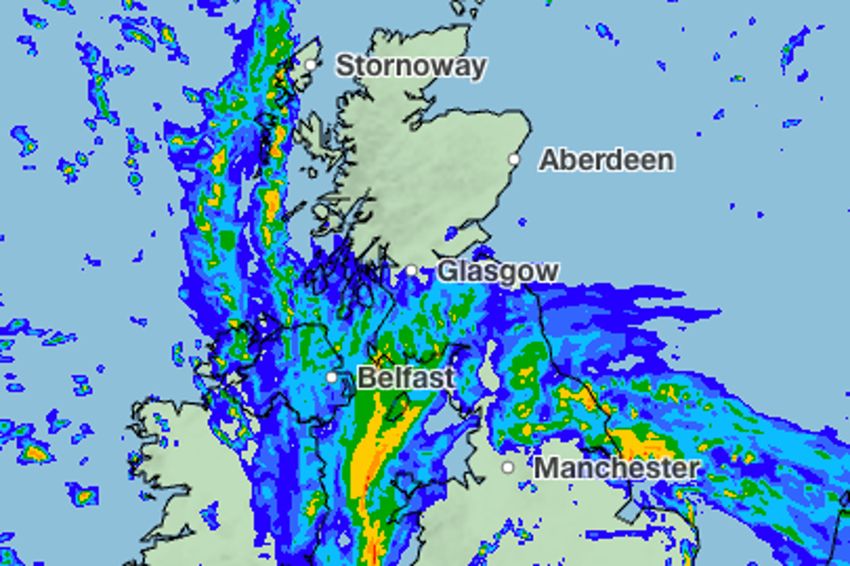
Powerful winds reaching almost 80mph and heavy rain is forecast to batter parts of the UK this week.
Storm Austen is expected to hit the country late on Thursday as an area of low pressure formed in the Atlantic rapidly deepens over the south west of England and Wales.
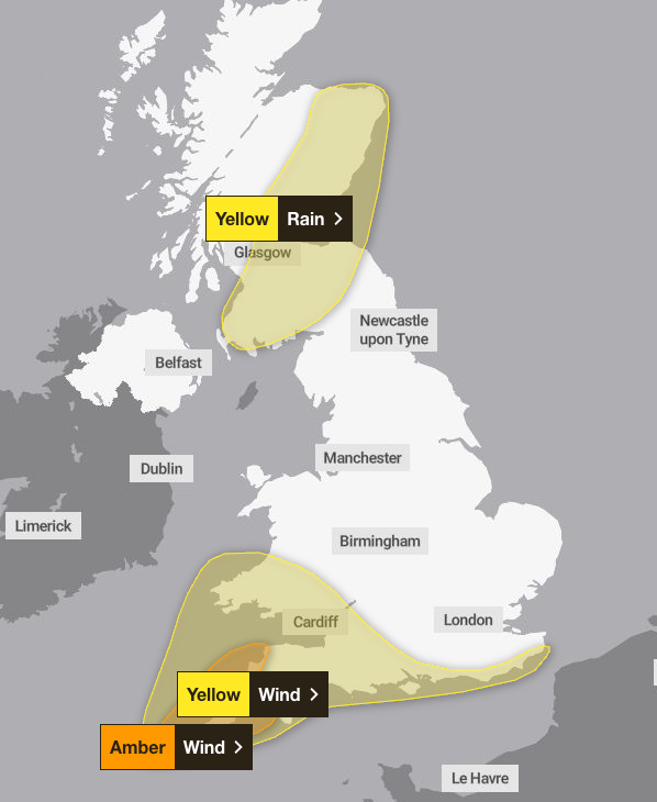
Forecasters have issued three weather warnings ahead of the storm alongside a “danger to life” warning along sea fronts and coastal roads due to large waves and thrown beach debris.
An amber weather warning is in place across Cornwall and parts of Devon between 3am and 10am on Friday.
Very strong northwesterly winds could reach 80mph in the south west which could damage buildings, bring down trees and cause disruption to power supplies and other utilities.
Exposed roads and bridges may also be affected, while rough seas could disrupt maritime travel through the English Channel and create dangerous conditions around some beaches, the Met Office has warned.
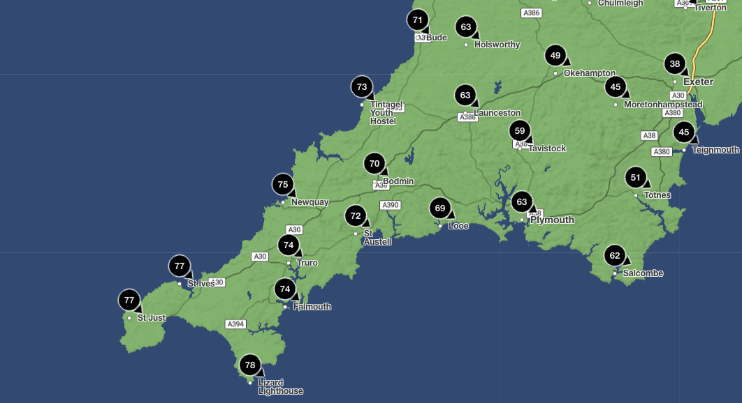
The Met Office weather map reveals in the most southerly point of Cornwall, The Lizard, wind gusts could reach 78Mph at 6am on Friday, while St Ives could also see gusts of 77mph.
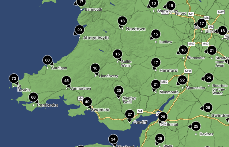
Areas of the south and west Wales are also expected to see winds of 50 to 60mph, with St Davids seeing wind gusts reaching 73mph.
A yellow weather warning for wind is also in place across southern England and south west Wales between midnight and 2pm on Friday.
Met Office Deputy Chief Forecaster Chris Bulmer said: “Storm Austen is expected to bring a spell of impactful weather to parts of the UK from Thursday night and through Friday. While there remains some uncertainty in the exact track of the storm, there is increasing confidence in the potential for disruptive winds across parts of southwest England, which is why an Amber warning has been issued.
“Winds gusts could potentially reach 60-70 mph for a time, and these strong winds will be combined with spells of heavy rain. People in affected areas should keep up to date with the latest forecast and warnings as the event develops.”
Storm Austen will move from west to east through Friday, with winds generally dying down later in the day.
A yellow weather warning for rain has been issued across parts of Scotland between 6am on Friday and 3am on Saturday.
Downpours across the Scottish borders, Glasgow, Edinburgh and Aberdeen could cause flooding, with accumulations of 20 to 40 mm expected widely and up to 80mm possible, bringing flooding and travel disruption in a few places. The rain will turn lighter and clear from the west through the evening and overnight.
The storm has been able to deepen rapidly because of its interaction with a powerful jet stream over the Atlantic, the Met Office explained.
As the storm crosses the jet stream and enters the “left jet exit region,” conditions high in the atmosphere support falling pressure at the surface, helping the low-pressure system strengthen rapidly.
UK five day weather forecast
Today:
A chilly start for many, with heavy showers soon clearing to leave a largely dry day with sunny spells. Turning increasingly cloudy across the southwest from mid-afternoon, with strengthening southerly winds as Storm Austen approaches.
Tonight:
Rain clearing the far north of Scotland, with clear spells developing inland. Heavy rain continues to move northwards across much of England and Wales as Storm Austen arrives.
Friday:
Rain will continue to move northwards on Friday as Storm Austen gradually clears. Winds will become strong and gusty, with gales and severe gales in places across the south.
Outlook for Saturday to Monday:
Strong winds and heavy rain Saturday before a brief settled interlude brings sunny spells and isolated light showers on Sunday. Further wind and rain arrives Monday.
KioskNews shows a cleaned-up reading view extracted from the publisher’s page — the original always lives on their site, not ours.