Super Typhoon Champi enters PAR, named Rosal
Already have Rappler+?
to listen to groundbreaking journalism.
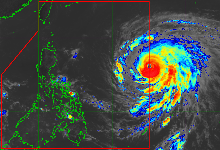
ROSAL. Satellite image of Super Typhoon Rosal (Champi) as of October 19, 2026, 10:40 am.
PAGASA
Signal No. 1 is raised in parts of Luzon at 11 am on Tuesday, October 20, shortly after the entry of Super Typhoon Rosal (Champi) into the Philippine Area of Responsibility
AT A GLANCE
- Super Typhoon Champi entered the Philippine Area of Responsibility on Tuesday, October 20. Its local name is Rosal.
- PAGASA raised Signal No. 1 in several areas to give them lead time of 36 hours to prepare for strong winds from Rosal.
This is AI-generated. Read the article for full context. Report any errors.
MANILA, Philippines – Super Typhoon Champi entered the Philippine Area of Responsibility (PAR) at 10:40 am on Tuesday, October 20, becoming the country’s 18th tropical cyclone for 2026.
Champi, also the first tropical cyclone for October, was given the local name Rosal.
In a press conference past 11 am on Tuesday, the Philippine Atmospheric, Geophysical, and Astronomical Services Administration (PAGASA) said Rosal was located 1,385 kilometers east of Central Luzon as of 10 am, moving west northwest at 25 kilometers per hour (km/h).
At the time of its entry, the super typhoon had maximum sustained winds of 185 km/h and gustiness of up to 230 km/h. On Monday evening, October 19, its maximum sustained winds had reached 195 km/h.
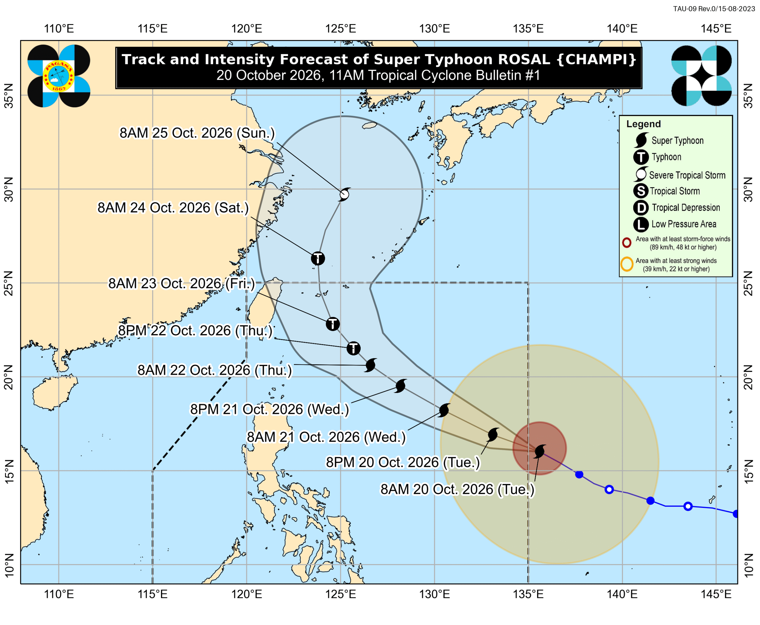
Rosal’s latest forecast track shows it is unlikely to make landfall in the Philippines. But due to its size and intensity, the super typhoon will still affect parts of the country.
Even before Rosal entered PAR, PAGASA already said on Monday that the trough or extension of the super typhoon may bring scattered rain and thunderstorms to Catanduanes, Northern Samar, and Eastern Samar. Flash floods and landslides can occur.
The weather bureau added on Tuesday morning that it may issue a rainfall advisory in the afternoon, listing the areas expected to see heavy rain from Rosal.
For strong winds, PAGASA already raised Signal No. 1 at 11 am on Tuesday, giving the affected areas lead time of 36 hours to prepare. These areas include:
- Batanes
- eastern part of Babuyan Islands (Babuyan Island, Camiguin Island, Didicas Island)
- eastern part of mainland Cagayan (Santa Ana, Gonzaga, Lal-lo, Santa Teresita, Camalaniugan, Aparri, Buguey, Gattaran, Baggao, Peñablanca)
- northeastern part of Isabela (Maconacon, Divilacan, Palanan, San Pablo, Cabagan, Santa Maria, Tumauini, Ilagan City)
- northeastern part of Catanduanes (Pandan, Bagamanoc, Panganiban, Viga, Gigmoto)
The highest possible tropical cyclone wind signal due to Rosal is Signal No. 2 or 3.
The northeasterly windflow and the periphery or outer bands of the super typhoon will also bring strong to gale-force gusts to the following areas:
Tuesday, October 20
- Batanes, Ilocos Norte, Cagayan, Isabela, Polillo Islands, Camarines Norte, Camarines Sur, Catanduanes, Northern Samar, Eastern Samar, most of Caraga, Camiguin, Misamis Oriental, Sarangani, Davao del Sur, Davao Occidental
Wednesday, October 21
- Ilocos Region, Cordillera Administrative Region, Cagayan Valley, Polillo Islands, Bicol, Romblon, Eastern Visayas, Iloilo, Guimaras, Negros Occidental, Siquijor, Bohol, Northern Mindanao, Caraga, Davao Region, Sarangani, Zamboanga del Norte
Thursday, October 22
- most of the country
In the next 24 hours, Rosal will also affect conditions in various seaboards across the country.
Up to very rough seas (travel is risky for all vessels)
- Northern and eastern seaboards of Catanduanes – waves up to 4.5 meters high
Up to rough seas (small vessels should not venture out to sea)
- Seaboard of Isabela; eastern seaboards of Batanes, Babuyan Islands, and mainland Cagayan; northern seaboards of Camarines Norte and Camarines Sur; northern and eastern seaboards of Northern Samar and Eastern Samar – waves up to 4 meters high
- Northern and eastern seaboards of Polillo Islands; eastern seaboards of Albay and Sorsogon; remaining seaboard of Batanes – waves up to 3.5 meters high
- Seaboards of Aurora and northern Quezon; eastern seaboards of Dinagat Islands and Siargao-Bucas Grande Island Group; remaining seaboards of Cagayan and Camarines Norte – waves up to 3 meters high
Up to moderate to rough seas (small vessels should take precautionary measures or avoid sailing, if possible)
- Seaboard of Surigao del Sur; eastern seaboard of Davao Oriental; remaining seaboard of Catanduanes – waves up to 2.5 meters high
- Seaboards of Ilocos Norte, Ilocos Sur, Surigao del Norte, and Davao Occidental; northern and eastern seaboards of Quezon; southern seaboard of Davao Oriental; remaining northern and eastern seaboards of Camarines Sur; remaining seaboards of Polillo Islands, Dinagat Islands, and Siargao-Bucas Grande Island Group – waves up to 2 meters high
PAGASA said Rosal will move generally west northwest until Wednesday, October 21, before heading generally northwest until Friday morning, October 23. Afterwards, it may turn north northwest to north starting Friday afternoon, until it leaves PAR by Friday evening or early Saturday morning, October 24.
The weather bureau also sees possible intensification in the next 24 hours as Rosal moves over the Philippine Sea, but it could weaken into a typhoon on Thursday, October 22, and into a severe tropical storm on Saturday evening or by Sunday morning, October 25.
ALSO ON RAPPLER
- GCash debuts on stock market with record P60.9-B IPO
- Notarization is finally available online. Here’s how it works.
- Gawilan bags Philippines’ first gold at 2026 Asian Para Games
- Alex Eala kicks off Ningbo Open campaign with win over Diane Parry
Aside from the trough of the super typhoon, other sources of rain on Tuesday include the intertropical convergence zone (ITCZ) and the easterlies.
The ITCZ is a belt near the equator where the trade winds of the Northern Hemisphere and the Southern Hemisphere meet, while the easterlies are warm winds from the Pacific Ocean.
Scattered rain and thunderstorms continue to hit Palawan due to the ITCZ, while isolated rain showers or thunderstorms may hit Batanes and Babuyan Islands because of the easterlies.
The Philippines is currently in a transition period to the northeast monsoon or amihan, following the end of the southwest monsoon or habagat, which was announced last October 5.
The northeast monsoon typically brings surges of cold temperatures, but the upcoming amihan period could be warmer as the existing strong El Niño in the tropical Pacific Ocean is predicted to become very strong in the fourth quarter of 2026. – Rappler.com
KioskNews shows a cleaned-up reading view extracted from the publisher’s page — the original always lives on their site, not ours.