[Column] Fixing the blurred border between South and North Korea
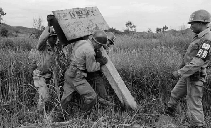
South Korean soldiers place a sign designating the Military Demarcation Line separating the two Koreas following the Korean War. (courtesy Defense Daily)

By Kwon Hyuk-chul, unification and international affairs editor
Korea’s Military Demarcation Line (MDL) and Demilitarized Zone (DMZ) have been the focus of renewed attention since the explosion of a suspected landmine in the western DMZ on Sept. 21. Some are now claiming that the North Korean military broke through the armistice line’s barbed-wire fences to plant mines.
The MDL and the armistice line are one and the same. “Military Demarcation Line” is the official term that appears in the Armistice Agreement signed on July 27, 1953. People tend to often use the term “armistice line” because it is shorter and simpler than “Military Demarcation Line.”
A common misconception is that the armistice line is lined with barbed-wire fences. Under the armistice pact, the MDL was set based on an invisible line that connected 1,292 markers stretching from the banks of the Imjin River in Paju, Gyeonggi Province, in the west to Goseong County, Gangwon Province, in the east.
Designation of the MDL was not a physical line of connected barbed-wire fences but a hand-drawn boundary on the map attached to the Armistice Agreement.
At the time, the United Nations Command (UNC), North Korea and China drew the MDL on a 1:50,000 scale map. But a discrepancy of several dozen meters in the line's exact location resulted in its width being about 50 meters on the ground.
The UNC and the North Korean military drove 1,292 stakes into the ground to mark the precise boundary, designating the imaginary line between them as the MDL. The management of these markers is central to managing the line, and the UNC was tasked with maintaining 696 of them and the North 596.
Such maintenance was halted after 1973. On March 7 of that year, North Korean troops suddenly opened fire on seven soldiers from the South Korean army's 3rd Division while the latter were replacing a damaged marker in the DMZ in Cheorwon County, Gangwon. Three casualties were reported.
In response, the division commander ordered artillery strikes using 105 mm and 155 mm howitzers on the North's frontline guard post that initiated the provocation, destroying it.
This incident led the UNC chief to impose a total ban on the repair of MDL markers, a restriction that remains in effect. Neglected for over 50 years, the original 1,292 markers are known to have succumbed to age, rust and floodwater, with just 181 remaining.
As the markers fell over and vanished, the MDL connecting them was also severed and lost. The DMZ, which no longer has the markers, has three distinct MDLs set by the South Korean military, the UNC and the North's military. Seoul mainly relies on the use of physical stakes to define the boundary but uses the coordinate lines shown on military maps when the markers are difficult to identify.
In 2004, South Korea collaborated with the US National Geospatial-Intelligence Agency to align the MDL on maps with the terrain, a task that continues to this day. From 2014 to 2016, the UNC converted the locations of the stakes into GPS coordinates, causing the MDL maps used by the South Korean military and the UNC to differ.
After the physical decline of the markers, the North's version of the MDL also diverged from the South's. While Seoul and the UNC use the GPS satellite navigation system, Pyongyang employs the Russian global navigation system GLONASS, making it difficult to confirm the MDL using GPS coordinates.
The MDL set by the Armistice Agreement is not a border, but rather a military control line meant to temporarily halt hostilities and separate the forces of both sides. The North recently declared inter-Korean relations to be those between two “hostile” states and began calling the MDL in October 2024 the "southern border."
Following this designation, the North's forces are moving to fortify the border by laying landmines and installing barbed-wire fences. Repeated incursions into the MDL by North Korean troops, which the South Korean military has responded to with warning broadcasts and shots, have heightened the risk of accidental clashes and other inter-Korean incidents.
The alleged explosion of a landmine in the DMZ on Sept. 21 occurred while soldiers from the South Korean Army's 25th Division were clearing a search path to check for a landmine supposedly planted by North Korean troops.
Behind this incident is a difference in perception between the two Koreas on the MDL's location. To prevent further incidents and accidental clashes in the DMZ, both sides and the UNC must urgently discuss setting a baseline for the MDL. Perhaps an agreement to at least reerect the fallen markers could be a start.
KioskNews shows a cleaned-up reading view extracted from the publisher’s page — the original always lives on their site, not ours.