LPA likely to develop into tropical depression on August 30; Saudel briefly reenters PAR
Already have Rappler+?
to listen to groundbreaking journalism.
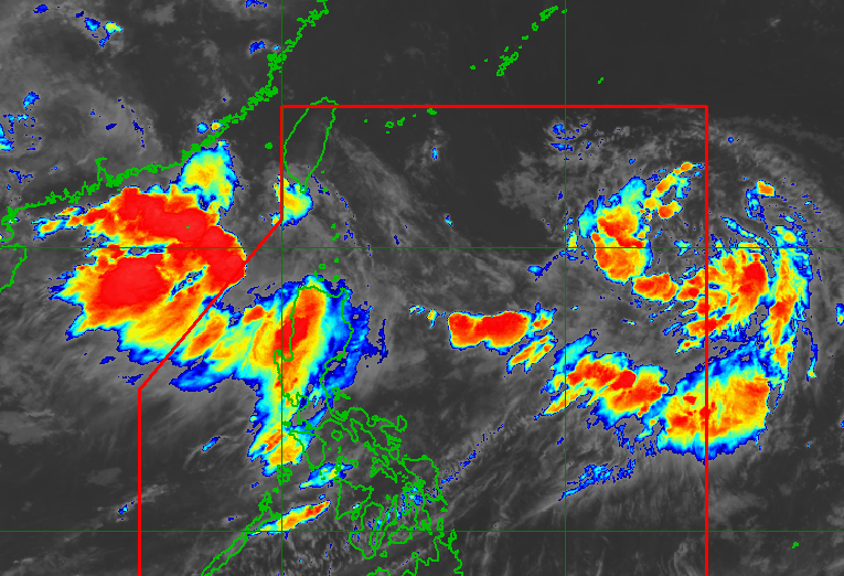
WEATHER. PAGASA monitoring the southwest monsoon, a low pressure area, and Tropical Depression Saudel as of August 30, 2026, 6:50 am.
PAGASA
Saudel is not directly affecting the country. What is still bringing rain to parts of Luzon is the southwest monsoon or habagat, causing monsoon rain in at least eight areas
AT A GLANCE
- A low pressure area in the Philippine Area of Responsibility has a high chance of developing into a tropical depression named Pilandok.
- Tropical Depression Saudel briefly reentered PAR but is not directly affecting the country, while the southwest monsoon is causing rain in various parts of Luzon.
- Heavy rainfall is expected in several areas over the next three days, with warnings for flash floods and landslides.
This is AI-generated. Read the article for full context. Report any errors.
MANILA, Philippines – A low pressure area now inside the Philippine Area of Responsibility (PAR) has a “high” chance of developing into a tropical depression on Sunday, August 30.
The Philippine Atmospheric, Geophysical, and Astronomical Services Administration (PAGASA) said the LPA, located at 1,340 kilometers east of extreme Northern Luzon, will be called the local name Pilandok once it strengthens.
Meanwhile, Tropical Depression Saudel (formerly referred to as Obet) briefly reentered PAR on Sunday and was located 1,105 km west northwest of extreme Northern Luzon, moving southwestward at 25 kilometers per hour, with maximum sustained winds of 45 km/h and gustiness of up to 75 km/h.
Saudel is not directly affecting the country, according to PAGASA Weather Specialist Obet Badrina.
What is still bringing rain to parts of Luzon is the southwest monsoon or habagat, causing monsoon rain in Ilocos Sur, Pangasinan, La Union, Benguet, Bataan, Zambales, Tarlac, and Pampanga.
It is also bringing occasional rain to Metro Manila, Ilocos Norte, the rest of the Cordillera Administrative Region, Nueva Vizcaya, Nueva Ecija, Bulacan, Rizal, Cavite, Laguna, Batangas, and Occidental Mindoro, scattered rain and thunderstorms to the rest of Luzon, Western Visayas, and Negros Island Region, and isolated rain showers or thunderstorms to the rest of the Visayas.
Badrina said the LPA could enhance the southwest monsoon again as it moves and strengthens. Below is PAGASA’s latest heavy rainfall outlook due to the southwest monsoon for the next three days:
Sunday, August 30
- Heavy to intense rain (100-200 millimeters): Ilocos Sur, Pangasinan, La Union, Benguet, Bataan, Zambales, Tarlac, and Pampanga
- Moderate to heavy rain (50-100 mm): Metro Manila, Ilocos Norte, Abra, Apayao, Kalinga, Ifugao, Mountain Province, Nueva Vizcaya, Nueva Ecija, Bulacan, Rizal, Cavite, Laguna, Batangas, and Occidental Mindoro
Monday, August 31
- Heavy to intense rain (100-200 millimeters): Ilocos Norte, Ilocos Sur, La Union, Pangasinan, Abra, Benguet, Zambales, and Bataan
- Moderate to heavy rain (50-100 mm): Apayao, Kalinga, Ifugao, Mountain Province, Tarlac, Pampanga, Bulacan, Metro Manila, Rizal, Cavite, Batangas, and Occidental Mindoro
Tuesday, September 1
- Heavy to intense rain (100-200 millimeters): Ilocos Norte, Ilocos Sur, Abra, Benguet, and Zambales
- Moderate to heavy rain (50-100 mm): Batanes, Apayao, Kalinga, Ifugao, Mountain Province, La Union, Pangasinan, Tarlac, Bataan, and Pampanga
These areas should be alert against flash floods and landslides. – Rappler.com
KioskNews shows a cleaned-up reading view extracted from the publisher’s page — the original always lives on their site, not ours.