Typhoon Saudel may strengthen monsoon upon PAR entry on Monday
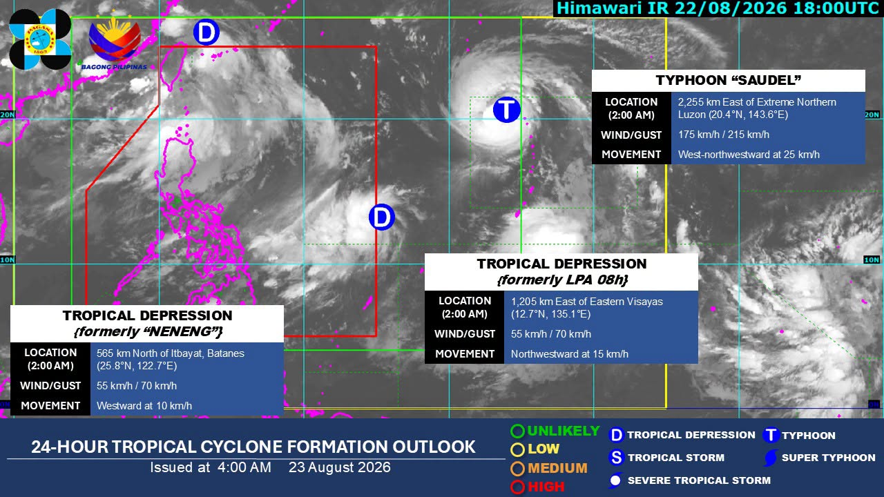

MANILA, Philippines — Typhoon Saudel is forecast to strengthen the southwest monsoon, or “habagat,” upon entering the Philippine Area of Responsibility (PAR) on Monday (August 24), state meteorologists said.
In the 5 a.m. forecast on Sunday, Philippine Atmospheric, Geophysical and Astronomical Services Administration (Pagasa) weather specialist Obet Badrina explained that Saudel, currently outside the PAR, has a high chance of entering the PAR tomorrow.
“Malaki ang posibilidad na itong Saudel ay pinakaunang papasok sa PAR posible po by tomorrow… Inaasahan na once pumasok ng PAR ang bagyong Saudel, magpapalakas ito ng habagat,” Badrina reported.
Article continues after this advertisement
(There is a high possibility that Saudel will be the first to enter PAR, possibly tomorrow… It is expected that once typhoon Saudel enters PAR, it will strengthen the southwest monsoon.)
FEATURED STORIES
NEWSINFO
NEWSINFO
NEWSINFO
According to Pagasa, Saudel was last located 2,245 kilometers east of extreme northern Luzon, moving west-northwestward at 25 kilometers per hour.
It is carrying maximum sustained winds at 175 kph and gusts of up to 215 kph, Pagasa added.
READ: Moderate to heavy rains to affect Luzon areas on Saturday afternoon
Badrina also warned that another tropical depression may enter the PAR shortly after Saudel.
Article continues after this advertisement
He said: “Itong bagyo naman sa may silanagn ng Visayas, posibleng sumunod siya sa bagyong Saudel. So nagkakaroon sila ngayon ng interaction.”
(This storm in the eastern Visayas is likely to follow Typhoon Saudel. So they are now interacting.)
Article continues after this advertisement
The state meteorologist is referring to the tropical depression 1,205 km east of eastern Visayas, moving northwestward at 15 kph.
Pagasa said the tropical depression has maximum sustained winds of 55 kph and gusts of up to 70 kph.
Pagasa also expects the track of the tropical depression to shift, which may lessen its chances of entering the PAR.
“Base sa pinakabagong datos, itong tropical depression ay magsisimulang gumalaw pahilaga kaya medyo maliit na ang posibilidad na pumasok ng Philippine Area of Responsibility sa ngayon,” Badrina stated.
(Based on the latest data, this tropical depression will begin to move northward, so the possibility of entering the Philippine Area of Responsibility is relatively small at this time.)
Apart from the two cyclones, Pagasa is also monitoring the tropical depression that was previously Neneng.
Although Neneng weakened into a low-pressure area, it intensified again into a tropical depression, Badrina explained.
Your subscription could not be saved. Please try again.
Your subscription has been successful.
Presently, the tropical depression only has a low chance of re-entering the PAR as it is moving westward at 10 kph from 565 km north of Itbayat, Batanes. /apl
KioskNews shows a cleaned-up reading view extracted from the publisher’s page — the original always lives on their site, not ours.